place

University High School (New Jersey)

1977 establishments in New JerseyEducational institutions established in 1977High schools in Newark, New JerseyPublic high schools in Essex County, New JerseyPublic middle schools in New Jersey
Use American English from April 2020Use mdy dates from February 2021

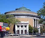
University High School of Humanities (usually University High School) is a six-year public high school serving students in seventh through twelfth grades in Newark, in Essex County, New Jersey, United States, as part of the Newark Public Schools. Originally created as a program called "School Within a School" at Malcolm X Shabazz High School, University High School became a standalone school in 1977. It moved into the old Clinton Place Junior High building in 1982.As of the 2021–22 school year, the school had an enrollment of 464 students and 41.0 classroom teachers (on an FTE basis), for a student–teacher ratio of 11.3:1. There were 354 students (76.3% of enrollment) eligible for free lunch and 38 (8.2% of students) eligible for reduced-cost lunch.

Excerpt from the Wikipedia article University High School (New Jersey) (License: CC BY-SA 3.0, Authors).

University High School (New Jersey)
Millington Avenue, Newark

Geographical coordinates (GPS) Address External links Nearby Places
placeShow on map

Wikipedia: University High School (New Jersey)Continue reading on Wikipedia

Geographical coordinates (GPS)

Latitude Longitude
N 40.72104 ° E -74.210697 °
placeShow on map

Address

University High School

Millington Avenue
07108 Newark
New Jersey, United States
mapOpen on Google Maps

linkWikiData (Q7894739)
linkOpenStreetMap (424473361)

Share experience

Nearby Places

Clinton Hill, Newark

Clinton Hill is a neighborhood within the south-central portion of the city of Newark in Essex County, New Jersey, United States. It is centered at Clinton Avenue, and bounded roughly by Elizabeth Avenue in the east, Hawthorne Avenue in the south, Avon Avenue in the north, and Irvington in the west. Upper Clinton Hill is predominantly residential, with many of the homes also being the offices of professionals. Most retail activity along Clinton and Hawthorne Avenues is in the form of neighborhood-oriented convenience-type stores. Residents can patronize a shopping center on Chancellor Avenue near the Irvington border or one on nearby Springfield Ave. Nearest to the commercial streets, the housing is largely two- and three-family conversions, while the interior streets include many large, well-maintained single-family houses. To the south, near I-78, are several vacant and abandoned properties. There is some light industry in the southeastern part of the neighborhood. Hawthorne Hill is the southwest section of Upper Clinton Hill. The Hawthorne Hill/Upper Clinton Hill neighborhoods are served by the Newark Public Library's Madison branch. M&M's first factory was at 285 Badger Avenue in the neighborhood. It is now a vacant lot.Newark's highest concentration of vacant land and empty buildings can be found in the Lower Clinton Hill neighborhood. Whole blocks of vacant land can be seen, much of it cleared of all but a few clusters of older residences. Indeed, more than half the neighborhood is vacant land. There is some commercial activity along Avon Avenue and at the intersection of Peddie Street and Elizabeth Avenue and a scattering of small, convenience-oriented businesses on Clinton Avenue and Bergen Street. The Lower Clinton Hill neighborhood is served by the Newark Public Library's Clinton branch.

Newark School of Fine and Industrial Art

Newark School of Fine and Industrial Art (NSFIA) was a city-run vocational and art school in Newark, New Jersey. Opened in 1882 as the Evening Drawing School, its name was changed in 1909 to the Fawcett School of Industrial Arts, and changed again in 1928 to the Newark Public School of Fine and Industrial Art. The name was shortened to Newark School of Fine and Industrial Art some time later. It moved into a new building in 1931.A number of well-known artists served on the faculty at Newark over the years, including the prolific illustrator and graphic designer Irv Docktor and painter John R. Grabach. Others included Enid Bell, Gustave Cimiotti, Hannes Beckman (design and color), Hillaire Hiler (color), Joseph Konzal (sculpture), Gerson Leiber (print making), Leopold Matzal (portrait), Reuben Nakian (sculpture), Robert Conover, Leo Dee, Jane Burgio, and Grigory Gurevich. Ida Wells Stroud taught there from c.1907 to 1943. The painter Avery Johnson taught at the Newark School from 1947 to 1960. In addition to teaching there, the painter Gustave Cimiotti, Jr. served as director of the school from 1935 to 1943. Henry Gasser, well known for his paintings of Newark, served as director from 1946 to 1954.The school closed its doors in 1997 when, in the midst of a budget crisis for the Newark public school system, it was decided that public schools would only operate K-12 schools. The school was originally housed within the same building as the Newark Arts High School. The college moved from that facility due to lack funding in the early 1990s and was relocated to Lyons Avenue until its 1997 closure.

West Side, Newark, New Jersey

The West Side is a neighborhood in the city of Newark in Essex County, New Jersey, United States. It is bounded on the east by Bergen Street, on the south by Rose Terrace and Avon Avenue, on the west by Irvington and on the north by South Orange Avenue. The main roads running through the neighborhood are Bergen Street, South Orange Avenue and Springfield Avenue. The mostly residential neighborhood is home to Woodland Cemetery and West Side Park. West Side High School and Chad Science Academy (closed down in 2005) (7-12) are also in this neighborhood. The area between 14th Street, 17th Avenue, 12th Avenue and Avon Avenue, once called Wolf's Harbor, is now the area around West Side Park. The area of Wolf's Harbor was once a large marsh that was home to several wolves. The area was renamed Magnolia Swamp after the tree when the wolves disappeared from the swamp. The swamp was filled in over time and eventually 14th Street cut through the middle of it after land was repeatedly filled in by Edward Keogh (an area that later was called Keogh's Hole). West Side Park, a county run park, was originally situated on a hill full of linden trees overlooking a lake, but the lake was later filled in to accommodate fields. Today the west side of the park remains elevated over the clear flat east side of the park and the hill was once used for skiing. There were once performances at the park, including Dionne Warwick and Whitney Houston.

Dayton, Newark

Dayton is a neighborhood within the city of Newark in Essex County, New Jersey. It is part of the city's south ward and was named after Jonathan Dayton, a Founding Father of the United States. The area is bounded on the north by Peddie Street (Thomas Baldwin Peddie), on the east by Newark Liberty International Airport, on the south by Elizabeth, and on the west by Elizabeth Avenue. The main road through the neighborhood is Frelinghuysen Avenue, but it is surrounded by U.S. Route 1/9, Interstate 78 and U.S. Route 22. The neighborhood of Dayton encompasses all of Weequahic Park, the second largest park in Newark. The park includes an 80-acre (320,000 m2) lake, Weequahic Golf Course and an old racetrack now used for jogging. The park has gospel and jazz concerts at night. The park is bisected by US 22 and the larger, southern section of the park (including Weequahic Lake) is easily accessible to Dayton.Jonathan Dayton (October 16, 1760 – October 9, 1824) was an American politician from the U.S. state of New Jersey. He was the youngest person to sign the United States Constitution and a member of the U.S. House of Representatives, serving as the fourth Speaker of the United States House of Representatives, and later the U.S. Senate. Years ago, the area of Dayton was also known for Twin City, a skating rink located on the Newark-Elizabeth border in the area of Virginia Street. St.Thomas Aquinas RC Church is located on Ludlow St. There is one train station in Dayton, Newark Liberty International Airport, served by New Jersey Transit's Northeast Corridor Line and North Jersey Coast Line, and Amtrak's Northeast Regional and Keystone Service. The station was built in 2001 to connect NJT's commuter lines and Amtrak's Northeast Corridor services with the airport's AirTrain system. It opened four years after service was run between terminals on the AirTrain. The station is only a transfer station and not publicly accessible by any roads. Proposal to extend PATH service to the airport may include a station at Dayton.