place

Temple B'Nai Abraham

Buildings and structures in Newark, New JerseyCulture of Newark, New JerseyEvangelical churches in New JerseyJews and Judaism in Newark, New JerseyNational Register of Historic Places in Newark, New Jersey
Neoclassical architecture in New JerseyNew Jersey Register of Historic PlacesNew Jersey Registered Historic Place stubsNew Jersey church stubsReligious buildings and structures in Essex County, New JerseySynagogues completed in 1924Synagogues in New JerseySynagogues on the National Register of Historic Places in New JerseyUnited States synagogue stubs
Bnai Abraham Deliverance Temple jeh

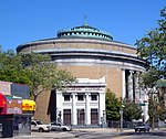
Temple B'nai Abraham is a synagogue in Livingston, New Jersey. It was established in Newark in 1853. Its historic 1924 building at 621 Clinton Avenue in was designed by Newark architect Nathan Myers, who later designed the iconic Hersch Tower in Elizabeth, New Jersey . In 1973, the congregation moved to Livingston and sold the building to the Deliverance Evangelistic Center, a Pentecostal Church. It was added to the National Register of Historic Places in 2007. Dr. Joachim Prinz, the rabbi from 1939 to 1976, modernized the ritual and introduced his own prayer book. Dr. Prinz, who had escaped Nazi Germany in 1937, became a vocal civil rights leader in the United States, known globally for his moving rhetoric. His successor, Rabbi Barry Friedman introduced further innovations in the services and wrote and edited the prayer book Siddur Or Chadash. In 1999, Rabbi Clifford Kulwin became the synagogue's fourth religious leader in 98 years. Rabbi David Z. Vaisberg became the next senior rabbi in 2019. For much of the 20th Century, Temple B'nai Abraham identified itself as a traditional progressive congregation, independent of the organized synagogue movements.

Excerpt from the Wikipedia article Temple B'Nai Abraham (License: CC BY-SA 3.0, Authors, Images).

Temple B'Nai Abraham
Clinton Avenue, Newark

Geographical coordinates (GPS) Address External links Nearby Places
placeShow on map

Wikipedia: Temple B'Nai AbrahamContinue reading on Wikipedia

Geographical coordinates (GPS)

Latitude Longitude
N 40.723055555556 ° E -74.206944444444 °
placeShow on map

Address

Deliverance Temple

Clinton Avenue 621
07108 Newark
New Jersey, United States
mapOpen on Google Maps

linkWikiData (Q7698428)
linkOpenStreetMap (423860919)

Bnai Abraham Deliverance Temple jeh
Share experience

Nearby Places

Clinton Hill, Newark

Clinton Hill is a neighborhood within the south-central portion of the city of Newark in Essex County, New Jersey, United States. It is centered at Clinton Avenue, and bounded roughly by Elizabeth Avenue in the east, Hawthorne Avenue in the south, Avon Avenue in the north, and Irvington in the west. Upper Clinton Hill is predominantly residential, with many of the homes also being the offices of professionals. Most retail activity along Clinton and Hawthorne Avenues is in the form of neighborhood-oriented convenience-type stores. Residents can patronize a shopping center on Chancellor Avenue near the Irvington border or one on nearby Springfield Ave. Nearest to the commercial streets, the housing is largely two- and three-family conversions, while the interior streets include many large, well-maintained single-family houses. To the south, near I-78, are several vacant and abandoned properties. There is some light industry in the southeastern part of the neighborhood. Hawthorne Hill is the southwest section of Upper Clinton Hill. The Hawthorne Hill/Upper Clinton Hill neighborhoods are served by the Newark Public Library's Madison branch. M&M's first factory was at 285 Badger Avenue in the neighborhood. It is now a vacant lot.Newark's highest concentration of vacant land and empty buildings can be found in the Lower Clinton Hill neighborhood. Whole blocks of vacant land can be seen, much of it cleared of all but a few clusters of older residences. Indeed, more than half the neighborhood is vacant land. There is some commercial activity along Avon Avenue and at the intersection of Peddie Street and Elizabeth Avenue and a scattering of small, convenience-oriented businesses on Clinton Avenue and Bergen Street. The Lower Clinton Hill neighborhood is served by the Newark Public Library's Clinton branch.

West Side, Newark, New Jersey

The West Side is a neighborhood in the city of Newark in Essex County, New Jersey, United States. It is bounded on the east by Bergen Street, on the south by Rose Terrace and Avon Avenue, on the west by Irvington and on the north by South Orange Avenue. The main roads running through the neighborhood are Bergen Street, South Orange Avenue and Springfield Avenue. The mostly residential neighborhood is home to Woodland Cemetery and West Side Park. West Side High School and Chad Science Academy (closed down in 2005) (7-12) are also in this neighborhood. The area between 14th Street, 17th Avenue, 12th Avenue and Avon Avenue, once called Wolf's Harbor, is now the area around West Side Park. The area of Wolf's Harbor was once a large marsh that was home to several wolves. The area was renamed Magnolia Swamp after the tree when the wolves disappeared from the swamp. The swamp was filled in over time and eventually 14th Street cut through the middle of it after land was repeatedly filled in by Edward Keogh (an area that later was called Keogh's Hole). West Side Park, a county run park, was originally situated on a hill full of linden trees overlooking a lake, but the lake was later filled in to accommodate fields. Today the west side of the park remains elevated over the clear flat east side of the park and the hill was once used for skiing. There were once performances at the park, including Dionne Warwick and Whitney Houston.

Dayton, Newark

Dayton is a neighborhood within the city of Newark in Essex County, New Jersey. It is part of the city's south ward and was named after Jonathan Dayton, a Founding Father of the United States. The area is bounded on the north by Peddie Street (Thomas Baldwin Peddie), on the east by Newark Liberty International Airport, on the south by Elizabeth, and on the west by Elizabeth Avenue. The main road through the neighborhood is Frelinghuysen Avenue, but it is surrounded by U.S. Route 1/9, Interstate 78 and U.S. Route 22. The neighborhood of Dayton encompasses all of Weequahic Park, the second largest park in Newark. The park includes an 80-acre (320,000 m2) lake, Weequahic Golf Course and an old racetrack now used for jogging. The park has gospel and jazz concerts at night. The park is bisected by US 22 and the larger, southern section of the park (including Weequahic Lake) is easily accessible to Dayton.Jonathan Dayton (October 16, 1760 – October 9, 1824) was an American politician from the U.S. state of New Jersey. He was the youngest person to sign the United States Constitution and a member of the U.S. House of Representatives, serving as the fourth Speaker of the United States House of Representatives, and later the U.S. Senate. Years ago, the area of Dayton was also known for Twin City, a skating rink located on the Newark-Elizabeth border in the area of Virginia Street. St.Thomas Aquinas RC Church is located on Ludlow St. There is one train station in Dayton, Newark Liberty International Airport, served by New Jersey Transit's Northeast Corridor Line and North Jersey Coast Line, and Amtrak's Northeast Regional and Keystone Service. The station was built in 2001 to connect NJT's commuter lines and Amtrak's Northeast Corridor services with the airport's AirTrain system. It opened four years after service was run between terminals on the AirTrain. The station is only a transfer station and not publicly accessible by any roads. Proposal to extend PATH service to the airport may include a station at Dayton.

1967 Newark riots

The 1967 Newark riots were an episode of violent, armed conflict in the streets of Newark, New Jersey. Taking place over a four-day period (between July 12 and July 17, 1967), the Newark riots resulted in at least 26 deaths and hundreds more serious injuries. Serious property damage, including shattered storefronts and fires caused by arson, left much of the city's buildings damaged or destroyed. At the height of the conflict, the National Guard was called upon to occupy the city with tanks and other military equipment, leading to iconic media depictions that were considered particularly shocking when shared in the national press. In the aftermath of the riots, Newark was quite rapidly abandoned by many of its remaining middle-class and affluent residents, as well as much of its white working-class population. This accelerated flight led to a decades-long period of disinvestment and urban blight, including soaring crime rates and gang activity. The Newark riots represented a flashpoint in a long-simmering conflict between elements of the city's then-growing African-American population, which had recently become a numerical majority, and its old political establishment, which remained dominated by members of non-African ethnic groups (especially Italian, Jewish, and Irish Americans) who had gained a political foothold in Newark during earlier generations. Endemic corruption in local government, combined with widespread racial prejudice, likely contributed to the city's failure, during the leadup to 1967, to include a more representative cross-section of the city's black population in its political power structure. Additionally, the Newark Riots were part of a larger national phenomenon, being among more than 150 race riots that occurred in the United States in the "Long Hot Summer of 1967". Some historians, focusing on the protest element of the conflict, have termed it the 1967 Newark Rebellion.