place

Cold Norton

Essex geography stubsMaldon DistrictVillages in Essex
Cold norton sign
Cold norton sign

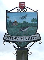
Cold Norton is a village on the Dengie Peninsula in Essex, England. It is located in rural countryside 10 miles to the east of Chelmsford, and lies just over a mile to the north of the River Crouch, which can be seen from the village's main hill. Nearby villages include Purleigh and North Fambridge. Administratively, Cold Norton forms part of the Purleigh ward in the district of Maldon.There are 412 dwellings, some industrial and commercial enterprises and the Three Rivers Golf and Country Club.There are two golf courses at Three Rivers Golf and Country Club, The 18 hole 6449 yard par 72 Kings Course and the smaller 18 hole par 64 Jubilee Course. Cold Norton Primary School is in St Stephens Road. The local parish church, St Stephen's, was the location of the first Church of England marriage ceremony to be conducted by a woman priest. The Stow Maries Aerodrome is situated within Cold Norton. It is a grade II listed World War I aerodrome built to defend London from zeppelin attack. 24 buildings remain standing, which have been sympathetically restored. The Norton Public House was reopened in August 2009 being run on a voluntary basis by local residents with the cooperation of the owners of the freehold. It was featured in the television series Save our Boozer shown on UKTV Blighty. The village hall has secured £348,500 from the Big Lottery Fund. The money comes from the lottery fund's community buildings programme.

Excerpt from the Wikipedia article Cold Norton (License: CC BY-SA 3.0, Authors, Images).

Cold Norton
Latchingdon Road, Essex

Geographical coordinates (GPS) Address Nearby Places
placeShow on map

Wikipedia: Cold NortonContinue reading on Wikipedia

Geographical coordinates (GPS)

Latitude Longitude
N 51.672236 ° E 0.668964 °
placeShow on map

Address

Latchingdon Road

Latchingdon Road
CM3 6GN Essex, Cold Norton
England, United Kingdom
mapOpen on Google Maps

Cold norton sign
Cold norton sign
Share experience

Nearby Places

North Fambridge railway station

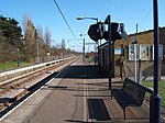
North Fambridge railway station is on the Crouch Valley Line in the East of England, serving the village of North Fambridge, Essex. It is 37 miles 27 chains (60.09 km) down the line from London Liverpool Street and is situated between South Woodham Ferrers to the west and Althorne to the east. The Engineer's Line Reference for the line is WIS; the station's three-letter station code is NFA. The southern (westbound) platform has an operational length for eight-coach trains while the northern (eastbound) platform can accommodate nine coaches.The line and station were opened for goods on 1 June 1889 and to passenger services on 1 October 1889 by the Great Eastern Railway. Facilities then included two platforms, both provided with buildings and linked by a footbridge; a goods yard including cattle pens; and a 30-lever signal box, reduced to 10 after 1966. The signal box was taken out of use on 1 December 1985 and demolished in February 1986. The original footbridge was replaced with a higher one prior to the electrification of the line in 1986. Electrification using 25 kV overhead line electrification (OLE) was completed on 12 May 1986. North Fambridge station is currently managed by Greater Anglia, which also operates all trains serving it. The typical off-peak service is of one westbound train every 40 minutes to Wickford and one eastbound train every 40 minutes to Southminster, with additional services at peak times. Some peak services continue to or from Shenfield and/or London Liverpool Street via the Great Eastern Main Line. As North Fambridge is at the midpoint of this single-track line, its double-track configuration provides a passing loop to allow two trains to run on the line at any one time. The station was originally called Fambridge (with the code FAM) but this was changed to North Fambridge on 20 May 2007.