place

Santa Ynez Mountains
Los Padres National ForestMontecito, CaliforniaMountain ranges of Santa Barbara County, CaliforniaMountain ranges of Southern CaliforniaMountain ranges of Ventura County, California
Ojai Ranger District, Los Padres National ForestSanta Barbara, CaliforniaSanta Barbara Ranger District, Los Padres National ForestSanta Ynez MountainsTransverse RangesUse mdy dates from March 2022
UpperArroyoBurro
UpperArroyoBurro

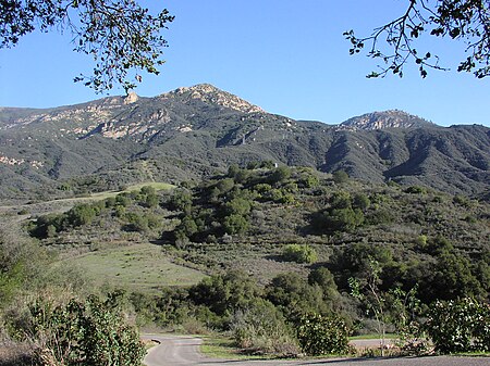
The Santa Ynez Mountains are a portion of the Transverse Ranges, part of the Pacific Coast Ranges of the west coast of North America. It is the westernmost range in the Transverse Ranges. The range is a large fault block of Cenozoic age created by the movements of the Santa Ynez Fault. A very narrow range, the Santa Ynez Mountains rise quickly on its north side and drops off equally dramatically along the range's south face along the Gaviota Coast. The Santa Ynez Mountains begin as a series of volcanic hills near Point Arguello, and gradually transitions eastward into a single, well-defined ridge extending from Gaviota Peak to Matilija Creek. The range is approximately contiguous with the Topatopa Mountains beyond to the east, which terminates abruptly at Sespe Creek. The climate of the range is Mediterranean with most of the precipitation falling between November and March. Most of the range lies in the California chaparral and woodlands ecoregion. At the crest and on the north slope, the rainier regions support extensive oak woodlands, mixed with other broadleafed species such as madrone, sycamore and bay laurel, along with some conifers, primarily Coulter pines.

Excerpt from the Wikipedia article Santa Ynez Mountains (License: CC BY-SA 3.0, Authors, Images).

Santa Ynez Mountains
Burg, Velden (VGem)

Geographical coordinates (GPS) Address Website Nearby Places
placeShow on map

Wikipedia: Santa Ynez MountainsContinue reading on Wikipedia

Geographical coordinates (GPS)

Latitude Longitude
N 34.5009 ° E -119.72969 °
placeShow on map

Address

Burg Hartenstein

Burg 1
91235 Velden (VGem)
Bayern, Deutschland
mapOpen on Google Maps

Website
burg-hartenstein.com

linkVisit website

UpperArroyoBurro
UpperArroyoBurro
Share experience

Nearby Places

La Cumbre Peak
La Cumbre Peak

La Cumbre Peak is a 3,997-foot (1,218 m) peak in the Santa Ynez Mountains north of Santa Barbara, California and located within the Los Padres National Forest. Composed of boulders and slabs of the Matilija Sandstone amid groves of pine trees, it is the highest summit in proximity to the city. Adjacent to La Cumbre is Arlington Peak (3,258 ft (993 m)) and Cathedral Peak (3,336 ft (1,017 m)). Other peaks within the Santa Ynez Range include Santa Ynez Peak, 15 miles (24 km) to the west, and Divide Peak, 15 miles (24 km) to the east. East Camino Cielo (originally known as Ridge Route) was constructed between October 1930 and June 1931 as a single lane road that extended 18 miles (29 kilometres) from San Marcos Pass to the summit of La Cumbre Peak. The intermittently curvaceous road was opened to the public, built with frequent turnouts and a set maximum speed limit of 15 mi (24 km) per hour. Today the road is frequently used by runners and cyclists for training, as the elevation gain is substantial and sustained, while there is relatively little car traffic. Construction of a fire lookout station upon the summit featuring a seasonal glass house was completed in the summer of 1923 by the US Forest Service, but may have been impacted by a fire that approached it from three sides in September of that year. In 1946, "La Cumbre Peak Lookout" was built to replace a California Region 5 Plan 4AR cabin that was mounted on a 10 ft (3.0 m) open timber tower. Utilizing an "innovative experimental design" that employed relatively high walls and sloped glass, the newer structure was considered to be expensive for its time (at a cost of $6,500) and was therefore the only model of its type to be constructed. The lookout was listed in the National Historic Lookout Register on June 19, 2010.

Chumash Painted Cave State Historic Park

Chumash Painted Cave State Historic Park is a unit in the state park system of California, United States, preserving a small sandstone cave adorned with rock art attributed to the Chumash people. Adjoining the small community of Painted Cave, the site is located about 2 miles (3.2 km) north of California State Route 154 and 11 miles (18 km) northwest of Santa Barbara. The 7.5-acre (3.0 ha) park was established in 1976. The smooth and irregularly shaped shallow sandstone cave contains numerous drawings apparently depicting the Chumash cosmology and other subjects created in mineral pigments and other media over a long period ranging from about 200 up to possibly 1000 years or more. There is also evidence of graffiti beginning with early white settlers, which eventually led to creation of a protective physical barrier and State Historic Park status. In 1972 it was added as Site #72000256 on the National Register of Historic Places.Access is from State Route 154 about 5 miles (8.0 km) north of U.S. Route 101 in the San Marcos Pass in the Santa Ynez Mountains, on Painted Cave Road. The cave is adjacent to the left side of this narrow one-lane mountain road, with a slightly widened shoulder that provides parking for one or two vehicles. The drive is not appropriate for trailers and RVs, due to some very tight turns and steep sections. This park is one of the few providing open access for viewing original rock art of the Chumash people in person. Flash photographs are prohibited since they can harm the artwork; some people use flashlights to help view the art, and some take photographs with long exposures with the camera braced on the metal gate or using a tripod.