place

Haagse Hout

Boroughs of The Hague
Haagse stadsdeel haagse hout

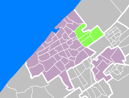
Haagse Hout (Dutch pronunciation: [ɦaːxsə ˈɦʌut], literally Woods of The Hague) is one of the eight districts of The Hague. This area was originally called Die Haghe Houte, which later became the current Haagse Hout. The district has 45,600 residents as of 2018. It is located in the north-east of the city, bordering Wassenaar to the north and Leidschendam-Voorburg to the east. Haagse Hout is divided into four neighbourhoods: Benoordenhout Bezuidenhout Mariahoeve en Marlot Haagse BosBezuidenhout is usually divided further into Bezuidenhout East and Bezuidenhout West. Mariahoeve and Marlot are also sometimes separately named. Villapark Marlot has the highest income of The Hague, and is one of the greener areas. The Haagse Bos is the largest green area, almost completely covered by parks and fields. This city park divides Haagse Hout into two: Benoordenhout and Bezuidenhout (literally North of the Woods and South of the Woods).

Excerpt from the Wikipedia article Haagse Hout (License: CC BY-SA 3.0, Authors, Images).

Haagse Hout
Barnsteenhorst, The Hague Haagse Hout

Geographical coordinates (GPS) Address Nearby Places
placeShow on map

Wikipedia: Haagse HoutContinue reading on Wikipedia

Geographical coordinates (GPS)

Latitude Longitude
N 52.0944 ° E 4.3548 °
placeShow on map

Address

Barnsteenhorst 480
2592 ET The Hague, Haagse Hout
South Holland, Netherlands
mapOpen on Google Maps

Haagse stadsdeel haagse hout
Share experience

Nearby Places

Bezuidenhout
Bezuidenhout

Bezuidenhout (Dutch pronunciation: [bəˈzœydə(n)ˌɦʌut]; English: "South of the Wood") is the neighborhood (Dutch: wijk) southeast of the Haagse Bos neighborhood of The Hague in the Netherlands. Bezuidenhout includes the Beatrixkwartier financial area near the Central Station and streets such as Bezuidenhoutseweg, Juliana van Stolberglaan, Laan van Nieuw Oost-Indië, Prins Clauslaan, and Theresiastraat. Part of German-occupied Europe during World War II, Bezuidenhout was bombed by mistake by the Royal Air Force in a bombing raid which killed hundreds of civilians. The targeted area was the adjacent woodland park Haagse Bos that was used by the Germans for launching V-1 and V-2 rockets, but all bombs missed the forest target by more than 500 yards (460 m) because of an error in reading the map, overcast conditions and incorrect allowance for the wind. The mistake caused the deaths of 511 civilians.Because nobody was certain about what to do after the explosion, there were no plans to reconstruct the neighbourhood until 1962, when David Jokinen saw an opportunity to put an end to the situation in which the Staatsspoor station and the Hollands Spoor each served only part of the rail traffic. His plan included demolishing the Staatsspoor Station. His plan sparked fierce discussions. The plan was not implemented, in part because it was only presented when decision-making had finally reached an advanced stage. Today, the Den Haag Centraal railway station stands in place of the Staatsspoor station.