place

Haagse Bos

Forests of the NetherlandsNeighbourhoods of The HagueParks in South HollandUrban public parks
Map NL 's Gravenhage Wijk 24 Haagse Bos

Haagse Bos (Dutch pronunciation: [ɦaːxsə ˈbɔs], literally Forest of The Hague) is a rectangular neighbourhood and forest in the Haagse Hout district of The Hague, Netherlands, reaching from the old city centre in the south-west to the border of Wassenaar in the north-east. It is also one of the oldest remaining forests of the country. During World War II, the park was used by the Germans for launching V-1 and V-2 rockets.

Excerpt from the Wikipedia article Haagse Bos (License: CC BY-SA 3.0, Authors, Images).

Haagse Bos
Ary Schefferstraat, The Hague Haagse Hout

Geographical coordinates (GPS) Address Website External links Nearby Places
placeShow on map

Wikipedia: Haagse BosContinue reading on Wikipedia

Geographical coordinates (GPS)

Latitude Longitude
N 52.090277777778 ° E 4.3333333333333 °
placeShow on map

Address

Haagse Bos

Ary Schefferstraat
2597 VR The Hague, Haagse Hout
South Holland, Netherlands
mapOpen on Google Maps

Website
staatsbosbeheer.nl

linkVisit website

linkWikiData (Q2663130)
linkOpenStreetMap (6315615)

Map NL 's Gravenhage Wijk 24 Haagse Bos
Share experience

Nearby Places

Netkous
Netkous

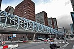
The Netkous or Fishnets is the popular name for the tram bridge in The Hague district Bezuidenhout built between 2004 and 2006. The viaduct is along the Prinses Beatrixlaan. An important part of light rail is the coupling of the Hague tram to the Zoetermeer City Line (formerly part of the NS). To make this possible, it was decided to build a branch of the Hague tram elevated between Ternoot to the railway station Laan van NOI, where it connects to the existing line. In the business area Beatrixkwartier to improve access, a station was built halfway along the viaduct. Before construction could begin the first station Ternoot was moved a few hundred meters, otherwise, there would be no room for the curve CS Beatrixlaan. Both the viaduct and the integrated station were designed by Zwarts & Jansma Architects. The overpass is built up of an open tubular structure, which is reminiscent of a fishnet stocking. Due to this strong construction are relatively large spans possible and the number of columns can remain limited. The viaduct segments are assembled on site, prefabricated steel rings and tubes. To do this, a temporary assembly was built on the route. In a special conserving hall (composed of shipping containers) the viaduct parts were provided with a protective coating. The viaduct is ridden by light rail 3 and 4. A similar fishnet structure applied in 2014 at the Railway bridge over the Dieze and The Royal Welsh Bridge in 's-Hertogenbosch, and is applied to the complete 2016 terminal of the Rotterdam metro line E between Slinge and The Hague Central.

Nationaal Archief
Nationaal Archief

The Nationaal Archief (NA) is the national archives of the Netherlands, located in The Hague. It houses collections for the central government, the province of South Holland, and the former County of Holland. There is also material from private institutions and individuals with an association to the Dutch government or the political or social history of the Netherlands. The Nationaal Archief holds the Archives of the Dutch East India Company from 1602–1811, which were, along with related records held by South Africa, India, Sri Lanka and Indonesia, inscribed on UNESCO's Memory of the World Programme Register in 2003 in recognition of their historical value. Recently, the photographic archives of Spaarnestad Photo were included in the Nationaal Archief. It has been announced that Wikipedia will receive user rights over many photos from these archives.The Netherlands Antilles had a separate Nationaal Archief, which was dissolved when the dissolution of the Netherlands Antilles took place. The entrance links to a walkway leading to the sister organizations housed in the same building. The large complex comprises a large apparatus to keep documents stored in optimum conditions, which the NA maintains (with government subsidies) for its sister organizations. The list of organizations housed in the complex adjoining The Hague Central Station are: Spaarnestad Photo archive (formerly of Haarlem) Biografisch Portaal The Koninklijke Bibliotheek (KB) The Centraal Bureau voor Genealogie (CBG) The Digital Library for Dutch Literature (DBNL) (formerly of Leiden) Data Archiving and Networked Services (DANS) The International Institute of Social History (IISG) The Onderzoekscentrum voor Geschiedenis en Cultuur (OGC), The Parlementair Documentatie Centrum (PDC) The Netherlands Institute for Art History (RKD) The Netherlands Music Institute (NMI) The Huygens Institute for the History of the Netherlands (Huygens ING) Letterkundig Museum (LM)

Bezuidenhout
Bezuidenhout

Bezuidenhout (Dutch pronunciation: [bəˈzœydə(n)ˌɦʌut]; English: "South of the Wood") is the neighborhood (Dutch: wijk) southeast of the Haagse Bos neighborhood of The Hague in the Netherlands. Bezuidenhout includes the Beatrixkwartier financial area near the Central Station and streets such as Bezuidenhoutseweg, Juliana van Stolberglaan, Laan van Nieuw Oost-Indië, Prins Clauslaan, and Theresiastraat. Part of German-occupied Europe during World War II, Bezuidenhout was bombed by mistake by the Royal Air Force in a bombing raid which killed hundreds of civilians. The targeted area was the adjacent woodland park Haagse Bos that was used by the Germans for launching V-1 and V-2 rockets, but all bombs missed the forest target by more than 500 yards (460 m) because of an error in reading the map, overcast conditions and incorrect allowance for the wind. The mistake caused the deaths of 511 civilians.Because nobody was certain about what to do after the explosion, there were no plans to reconstruct the neighbourhood until 1962, when David Jokinen saw an opportunity to put an end to the situation in which the Staatsspoor station and the Hollands Spoor each served only part of the rail traffic. His plan included demolishing the Staatsspoor Station. His plan sparked fierce discussions. The plan was not implemented, in part because it was only presented when decision-making had finally reached an advanced stage. Today, the Den Haag Centraal railway station stands in place of the Staatsspoor station.