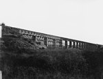
High Bridge (Appomattox River)

High Bridge is a historic former railroad bridge across the Appomattox River valley about 6 miles (9.7 km) east, or downstream, of the town of Farmville in Prince Edward County, Virginia. The remains of the bridge and its adjacent rail line are now a rail trail park, High Bridge Trail State Park. Originally constructed in the 1850s, the bridge was integral to the Southside Railroad between Petersburg and Lynchburg. As the site of the Battle of High Bridge in April 1865, the bridge played a pivotal role in Lee's retreat in the final days of the American Civil War – and ultimately the war's outcome. Rebuilt after the Civil War to its former dimensions, the 21-span structure was 2,400 feet (730 m) long at a maximum height of 125 feet (38 m) above the Appomattox River Valley. The bridge was completely rebuilt in 1914, leaving many of the original masonry piers adjacent to the new structure. By 2005 its then-owner, Norfolk Southern, abandoned the corridor, subsequently giving 33 miles of the line to the Virginia Department of Conservation and Recreation (DCR). High Bridge opened to the public on April 6, 2012, the 147th anniversary of the Battle of High Bridge. The bridge is part of the completed trail, open to hiking, biking and horse back riding for 16 miles on either side of the bridge.
Excerpt from the Wikipedia article High Bridge (Appomattox River) (License: CC BY-SA 3.0, Authors, Images).High Bridge (Appomattox River)
High Bridge Trail,
Geographical coordinates (GPS) Address External links Nearby Places Show on map
Geographical coordinates (GPS)
| Latitude | Longitude |
|---|---|
| N 37.311388888889 ° | E -78.318333333333 ° |
Address
High Bridge Trail
High Bridge Trail
Virginia, United States
Open on Google Maps


