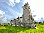
Wicklewood
Civil parishes in NorfolkNorfolk geography stubsVillages in Norfolk

Wicklewood is a village and civil parish in the South Norfolk district of Norfolk, England. It is located 11 miles (18 km) west of Norwich next to the market town of Wymondham, neighbouring the villages of Deopham, Hackford and Kimberley. It covers an area of 8.75 km2 (3.38 sq mi) and had a population of 886 in 345 households at the 2001 census, which had increased to 922 at the 2011 Census.The villages name probably means, 'wych-elm wood/clearing'. 'Wood' is redundant.
Excerpt from the Wikipedia article Wicklewood (License: CC BY-SA 3.0, Authors, Images).Wicklewood
High Street, South Norfolk Wicklewood
Geographical coordinates (GPS) Address Nearby Places Show on map
Geographical coordinates (GPS)
| Latitude | Longitude |
|---|---|
| N 52.580314 ° | E 1.061211 ° |
Address
High Street 80
NR18 9QA South Norfolk, Wicklewood
England, United Kingdom
Open on Google Maps


