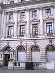
St James's
All accuracy disputesAreas of LondonCity of WestminsterDistricts of the City of WestminsterEngvarB from June 2013 ... and 1 more
St James's

St James's is a central district in the City of Westminster, London, forming part of the West End. In the 17th century the area developed as a residential location for the British aristocracy, and around the 19th century was the focus of the development of gentlemen's clubs. Once part of the parish of St Martin in the Fields, much of it formed the parish of St James from 1685 to 1922. Since the Second World War the area has transitioned from residential to commercial use. St James's is bounded to the north by Piccadilly and Mayfair, to the west by Green Park, to the south by The Mall bounding St. James's Park, and to the east by Haymarket.
Excerpt from the Wikipedia article St James's (License: CC BY-SA 3.0, Authors, Images).St James's
Carlton Street, City of Westminster Covent Garden
Geographical coordinates (GPS) Address Nearby Places Show on map
Geographical coordinates (GPS)
| Latitude | Longitude |
|---|---|
| N 51.5085 ° | E -0.133 ° |
Address
Carlton Street
SW1Y 4RG City of Westminster, Covent Garden
England, United Kingdom
Open on Google Maps


