Melsen

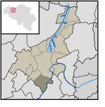
Melsen is a village in the province of East Flanders, Belgium, and is a part of the municipality of Merelbeke. It covers an area of roughly 3 square kilometers. Its terrain is largely made up of one great hill. The northern and southern slopes of the hill, which are fairly steep for the surrounding area (about 20 meters), form the natural boundaries with the bordering villages of Vurste and Schelderode. The eastern slopes of the hill evolve into agricultural land and farther east into the forest of Makkegem. The western slope descends into a marsh that is connected to the Schelde (Scheldt) river. Most of the land used to be for agricultural purposes, or covered with forests and marshes, but now most of the western and northern part of the village is almost fully covered by a network of streets and houses. Only some fields on the borders of the village remain.
Excerpt from the Wikipedia article Melsen (License: CC BY-SA 3.0, Authors, Images).Melsen
Meersstraat,
Geographical coordinates (GPS) Address Nearby Places Show on map
Geographical coordinates (GPS)
| Latitude | Longitude |
|---|---|
| N 50.966666666667 ° | E 3.7 ° |
Address
De Putten
Meersstraat
9820
East Flanders, Belgium
Open on Google Maps


