A660 road
Geographic coordinate listsInfobox road instances in the United KingdomInfobox road maps tracking categoryLists of coordinatesRoads in Yorkshire ... and 3 more
Transport in LeedsTransport in West YorkshireUse British English from February 2013

The A660 is a major road in the Leeds and Bradford districts of West Yorkshire, England that runs from Leeds city centre to Burley-in-Wharfedale where it meets the A65. (The A65 also starts in Leeds and runs parallel to, and south of, the A660. It continues to Ilkley, Skipton, Settle and Kendal as a main trans-Pennine route.) The A660 is approximately 10 miles (16 km) long, and crosses the watershed from Airedale to lower Wharfedale. For most of its length the road is in the metropolitan district of the City of Leeds; the last 0.4 miles (0.6 km) is in City of Bradford district.
Excerpt from the Wikipedia article A660 road (License: CC BY-SA 3.0, Authors, Images).A660 road
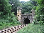
Leeds Road, Leeds Bramhope
Geographical coordinates (GPS) Address Nearby Places Show on map
Geographical coordinates (GPS)
| Latitude | Longitude |
|---|---|
| N 53.8793 ° | E -1.6049 ° |
Address
Leeds Road
Leeds Road
LS16 9EF Leeds, Bramhope
England, United Kingdom
Open on Google Maps


