place

Metro Manila Skyway

Accuracy disputes from June 2015All accuracy disputesInfobox road instances in the PhilippinesInfobox road maps tracking categoryInfobox road temporary tracking category 1
Pages with non-numeric formatnum argumentsRoads in Metro ManilaToll roads in the PhilippinesUse Philippine English from January 2021Use mdy dates from January 2021
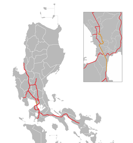
Metro Manila Skyway map

The Metro Manila Skyway, officially the Metro Manila Skyway System (MMSS) or simply the Skyway, is an elevated highway which is the main expressway in Metro Manila, Philippines. It connects the North and South Luzon Expressways (NLEX and SLEX) with access to Ninoy Aquino International Airport via the NAIA Expressway (NAIAX). It is the first fully grade-separated highway in the Philippines and one of the longest elevated highways in the world, with a total length of approximately 39.2 kilometers (24.4 mi). The expressway runs above major existing highways in Metro Manila and the San Juan River. It passes through the highly urbanized areas of Caloocan, Quezon City, Manila, Makati, Pasay, Taguig, Parañaque, and Muntinlupa, easing congestion on other major thoroughfares. The Skyway is accessible to Class 1 vehicles, such as cars, vans, motorcycles above 400 cc (24 cu in), pick-up trucks, and SUVs, and Class 2 vehicles and public utility vehicles (PUVs). Previously, Class 2 vehicles and PUVs were banned due to the construction of the extension project.

Excerpt from the Wikipedia article Metro Manila Skyway (License: CC BY-SA 3.0, Authors, Images).

Metro Manila Skyway
Skyway, Parañaque

Geographical coordinates (GPS) Address Nearby Places
placeShow on map

Wikipedia: Metro Manila SkywayContinue reading on Wikipedia

Geographical coordinates (GPS)

Latitude Longitude
N 14.506388888889 ° E 121.03527777778 °
placeShow on map

Address

Skyway

Skyway
1700 Parañaque
Philippines
mapOpen on Google Maps

Metro Manila Skyway map
Share experience

Nearby Places

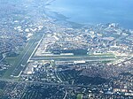
Ninoy Aquino International Airport

Ninoy Aquino International Airport (NAIA , locally ; Filipino: Paliparang Pandaigdig ng Ninoy Aquino; IATA: MNL, ICAO: RPLL), originally known as Manila International Airport (MIA), is the main international airport serving the city of Manila and the metropolitan area of the same name. Located between the cities of Pasay and Parañaque, about 7 kilometers (4.3 mi) south of Manila proper and southwest of Makati, NAIA is the main gateway for travelers to the Philippines and serves as a hub for AirSWIFT, Cebgo, Cebu Pacific, PAL Express, and Philippine Airlines; it is also the main operating base for Philippines AirAsia. Named after Senator Ninoy Aquino (1932–1983), who was assassinated at the airport on August 21, 1983, it is managed by the Manila International Airport Authority (MIAA), an agency of the Department of Transportation (DOTr).Officially, NAIA is the only airport serving the Metro Manila area. However, in practice, both NAIA and Clark International Airport, located in the Clark Freeport Zone in Pampanga, serve the metropolis. However, Clark caters mostly to low-cost carriers because of its lower landing fees compared to the higher fees at NAIA. Recently, there have been calls for Clark to replace NAIA eventually as the primary airport of the Philippines. In an effort to reduce congestion at the airport, two new airports are being constructed: New Manila International Airport, located in Bulacan, and Sangley Point Airport, located on reclaimed land in Cavite City.Currently, NAIA is operating beyond its designed capacity of 35 million passengers, causing air traffic congestion and flight delays. The airport has been tagged by The Guide to Sleeping In Airports, luggage storage app Bounce, and travel blog Hawaiian Islands as one of the worst airports in both Asia-Pacific, if not the world. Since 2018, plans to privatize and improve the airport have been pitched, and were revived again in 2023 following a major malfunction in the airport's air traffic control system.