place

Christ Church Lutheran (Minneapolis, Minnesota)
20th-century Lutheran churches in the United StatesChurches in MinneapolisChurches on the National Register of Historic Places in MinnesotaEero Saarinen church buildingsFinnish-American culture in Minnesota
Lutheran churches in MinnesotaModernist architecture in MinnesotaNational Historic Landmarks in MinnesotaNational Register of Historic Places in Minneapolis
Christ Church Lutheran NE

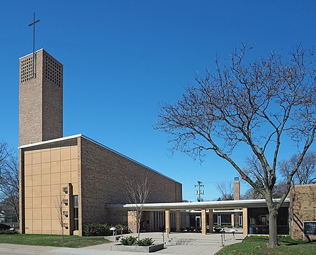
Christ Church Lutheran is a congregation of the Evangelical Lutheran Church in America (ELCA) in Minneapolis. Its buildings—a sanctuary with chapel (1949) and an education wing (1962) designed by Finnish-American architects Eliel Saarinen and Eero Saarinen—have been internationally recognized, most recently in 2009 as a National Historic Landmark by the U.S Department of the Interior. The congregation was established in 1911 as part of the Lutheran Church–Missouri Synod, but left in the 1970s as part of a dispute that led to the formation of the Association of Evangelical Lutheran Churches, which in turn was among the founding denominations of the ELCA. The Rev. Miriam Samuelson-Roberts currently serves as lead pastor, with the Rev. Erik Haaland as associate pastor. The congregation is also served by its cantors, the Rev. Robert Buckley Farlee and the Rev. Martin A. Seltz.

Excerpt from the Wikipedia article Christ Church Lutheran (Minneapolis, Minnesota) (License: CC BY-SA 3.0, Authors, Images).

Christ Church Lutheran (Minneapolis, Minnesota)
East 33rd Street, Minneapolis

Geographical coordinates (GPS) Address External links Nearby Places
placeShow on map

Wikipedia: Christ Church Lutheran (Minneapolis, Minnesota)Continue reading on Wikipedia

Geographical coordinates (GPS)

Latitude Longitude
N 44.943611111111 ° E -93.223333333333 °
placeShow on map

Address

Christ Church Lutheran

East 33rd Street
55406 Minneapolis
Minnesota, United States
mapOpen on Google Maps

linkWikiData (Q281123)
linkOpenStreetMap (5731324)

Christ Church Lutheran NE
Share experience

Nearby Places

Longfellow, Minneapolis

Longfellow is a defined community in Minneapolis, Minnesota which includes five smaller neighborhoods inside of it: Seward, Cooper, Hiawatha, Howe and Longfellow. The community is a mix of agri-industrial properties along the old Northern Pacific Railway, expansive parkland surrounding the famous Minnehaha Falls, and smaller residential areas. The community is grouped with South Minneapolis between the city's eastern border with the Mississippi River and the Metro Blue Line, Longfellow takes its name from Longfellow neighborhood which in turn is named after Henry Wadsworth Longfellow. The renowned American poet incorporated elements into his poem The Song of Hiawatha from Henry Schoolcraft's accounts of native Dakota lore in Minnesota which included Minnehaha Falls in Longfellow's southern tip. The early reference of Highway 55 as Hiawatha Avenue, along the west border, may have influenced the naming decision when community borders were drawn in the 1960s. Hiawatha Avenue is the main thoroughfare leading north into Downtown Minneapolis and south to the Minneapolis-Saint Paul Airport. Longfellow is home to the Danish American Center, Minnehaha Academy, Christ Church and the Longfellow House. The area is typically recognized by bungalow style Craftsman homes built in the 1920s. However it also contains the Ray and Kay Price House, designed by the famed Ralph Rapson, and the Frederick Lang House, designed by Herb Fritz. Minnehaha Falls is a national attraction and an important cultural node of the Twin Cities. The neighborhood's central corridor runs along 42nd Avenue South and is home to many businesses including the Riverview Theater, Turtle Bread Company, The Blue Door Pub and Mother Earth Gardens. Along the northern edge runs the Midtown Greenway trail and the vibrant East Lake business district, which is home to many award winning restaurants including Town Talk Diner, Sonora Grill, and The Bungalow Club. The west border was once an agri-industrial and milling processing center served by the Northern Pacific Railway. Today the grain silos and factories along the length of the highway are set to make way for new residential condos, apartment buildings, and a new greenway connecting Minnehaha Falls and the Midtown Greenway. This area is also anchored by the Minnehaha Mile, a biking street that contains more antique, vintage, retro, and secondhand shops than any other commercial corridor in the state of Minnesota