place

Cooper, Minneapolis

AC with 0 elementsMinnesota populated places on the Mississippi RiverNeighborhoods in Minneapolis
MinneapolisCooperNeighborhood

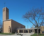
The Cooper neighborhood (part of the larger Longfellow community) resides along the west shore of the Mississippi River in south Minneapolis. It is bound by 34th St. E. on the south, 38th Ave. S. on the west, 27th St. E. on the north, and the river gorge to the east. Bordering neighborhoods are Seward to the north, Longfellow to the west, and Howe to the south. St. Paul's Merriam Park neighborhood is just across the Mississippi River to the east. Cooper was named after the 19th-century author James Fenimore Cooper, best known for writing The Last of the Mohicans (1832).

Excerpt from the Wikipedia article Cooper, Minneapolis (License: CC BY-SA 3.0, Authors, Images).

Cooper, Minneapolis
43rd Avenue South, Minneapolis

Geographical coordinates (GPS) Address Nearby Places
placeShow on map

Wikipedia: Cooper, MinneapolisContinue reading on Wikipedia

Geographical coordinates (GPS)

Latitude Longitude
N 44.94451 ° E -93.2117 °
placeShow on map

Address

43rd Avenue South 3212
55406 Minneapolis
Minnesota, United States
mapOpen on Google Maps

MinneapolisCooperNeighborhood
Share experience

Nearby Places

Longfellow, Minneapolis

Longfellow is a defined community in Minneapolis, Minnesota which includes five smaller neighborhoods inside of it: Seward, Cooper, Hiawatha, Howe and Longfellow. The community is a mix of agri-industrial properties along the old Northern Pacific Railway, expansive parkland surrounding the famous Minnehaha Falls, and smaller residential areas. The community is grouped with South Minneapolis between the city's eastern border with the Mississippi River and the Metro Blue Line, Longfellow takes its name from Longfellow neighborhood which in turn is named after Henry Wadsworth Longfellow. The renowned American poet incorporated elements into his poem The Song of Hiawatha from Henry Schoolcraft's accounts of native Dakota lore in Minnesota which included Minnehaha Falls in Longfellow's southern tip. The early reference of Highway 55 as Hiawatha Avenue, along the west border, may have influenced the naming decision when community borders were drawn in the 1960s. Hiawatha Avenue is the main thoroughfare leading north into Downtown Minneapolis and south to the Minneapolis-Saint Paul Airport. Longfellow is home to the Danish American Center, Minnehaha Academy, Christ Church and the Longfellow House. The area is typically recognized by bungalow style Craftsman homes built in the 1920s. However it also contains the Ray and Kay Price House, designed by the famed Ralph Rapson, and the Frederick Lang House, designed by Herb Fritz. Minnehaha Falls is a national attraction and an important cultural node of the Twin Cities. The neighborhood's central corridor runs along 42nd Avenue South and is home to many businesses including the Riverview Theater, Turtle Bread Company, The Blue Door Pub and Mother Earth Gardens. Along the northern edge runs the Midtown Greenway trail and the vibrant East Lake business district, which is home to many award winning restaurants including Town Talk Diner, Sonora Grill, and The Bungalow Club. The west border was once an agri-industrial and milling processing center served by the Northern Pacific Railway. Today the grain silos and factories along the length of the highway are set to make way for new residential condos, apartment buildings, and a new greenway connecting Minnehaha Falls and the Midtown Greenway. This area is also anchored by the Minnehaha Mile, a biking street that contains more antique, vintage, retro, and secondhand shops than any other commercial corridor in the state of Minnesota

Meeker Island Lock and Dam

The Meeker Island Lock and Dam (originally known as Lock and Dam No. 2) was the first lock and dam facility built on the Upper Mississippi River. Meeker Island was named after its owner Judge Bradley B. Meeker. Meeker County was named after him also. After a construction period lasting eight years, the site was only in operation for five years from 1907 to 1912 when the growing interest in hydroelectric power led to design and construction of today's Lock and Dam No. 1 a few miles downriver. It was realized that the new dam could take over the function provided by this first site and another small dam a short distance downriver. Lock and Dam No. 1 opened in 1917, and a hydroelectric plant was added there in the 1920s to power the Ford Motor Company's Twin Cities Assembly Plant. The Meeker Island dam was demolished, although some ruins of the lock remain. Tops of the old lock walls become visible during low water periods on the river. It is located in the Desnoyer Park neighborhood, north of the Lake Street-Marshall Bridge connecting Minneapolis and Saint Paul, Minnesota. The Meeker Island Lock and Dam ruins were added to the National Register of Historic Places in 2003. Each year, National Park Service historian Dr. John Anfinson and the Friends of the Mississippi River lead a tour of the lock and dam ruins. In 2005 a $380,000 restoration project began to create a public park near the dam. It was finished in 2007.The historic dam site and off-leash dog park are part of the Mississippi River Gorge Regional Park.

Short Line Bridge
Short Line Bridge

The Short Line Bridge is a truss bridge that spans the Mississippi River in Minneapolis, Minnesota, United States. It was originally built in the 1880s and upgraded a few years later by Chicago, Milwaukee, St. Paul and Pacific Railroad and was designed by American Bridge Company. The bridge is entirely within Minneapolis but the railroad line crosses into St. Paul less than a half mile to the east. The name "Short Line" comes from the Milwaukee Road's construction of a shorter, more direct connection between St. Paul and Minneapolis. Previously the connection was made via a line that headed southwest along the Mississippi River, north at Mendota and northwest via Fort Snelling to downtown Minneapolis. The "Short Line" was part of a number of construction projects in the 1880s that also included a roundhouse and yard near the present-day junction of Lake Street and Hiawatha Avenue, as well as a line to the west just north of Lake Street (today's Midtown Greenway). As railroad traffic became less important in the Twin Cities in the latter part of the 20th century, the Milwaukee Road gradually abandoned several of its lines in the area. It still found use for the Short Line Bridge route, however, as did Milwaukee Road successors Soo Line Railroad and Canadian Pacific. The bridge was also used by the Twin Cities and Western Railroad. Through trains continued to cross the bridge until the former Milwaukee Road was severed at Lake Street as part of the reconstruction of Hiawatha Avenue (Minnesota State Highway 55). The bridge is still used today by the Minnesota Commercial Railway to service grain elevators along Hiawatha Avenue. There has been some discussion about using the bridge as a connection for the Midtown Greenway across the Mississippi River, but Canadian Pacific has not been receptive to the idea.In July 2006 there was a severe fire on the bridge which caused $200,000 in damage, closing down rail traffic until it could be repaired. Originally the cause was thought to have been small fireworks, but later appeared to be arson, by dousing the bridge in gasoline. The bridge in the specific spot could only hold at maximum 50 pounds of weight. To prevent people from hurting themselves, local authorities patrolled each side of the bridge from 6:00 pm – 6:00 am in the days following the event. Now a fence blocking access to the bridge states that any trespassers will be fined and/or serve jail time. There was a smaller fire at an unknown date prior to this incident. The bridge was repaired within a few weeks in order to continue to serve a few customers of the west side of the river that had no other rail access aside from this line. Special ties were brought in from across the country to repair the damaged area.

Minneapolis–Saint Paul

Minneapolis–Saint Paul is a metropolitan area centered around the confluence of the Mississippi, Minnesota and St. Croix rivers in the U.S. state of Minnesota. It is commonly known as the Twin Cities after the area's two largest cities, Minneapolis and Saint Paul. Minnesotans often refer to the two together (or the seven-county metro area collectively) simply as "the cities". It is Minnesota’s economic, cultural, and political center. Minneapolis and Saint Paul are independent municipalities with defined borders. Minneapolis sits mostly on the west side of the Mississippi River on lake-covered terrain. Although most of the city is residential neighborhoods, it has a business-dominated downtown area with some historic industrial areas, the Mill District and the Warehouse District. Minneapolis also has a popular uptown area. Saint Paul, which sits mostly on the east side of the river, has quaint tree-lined neighborhoods, a vast collection of well-preserved late-Victorian architecture, and a number of colleges. Both cities and the surrounding areas are known for their woods, lakes, hills and creeks.Originally inhabited by the Ojibwe and Dakota people, the cities were settled by various Europeans. Minneapolis was strongly influenced by early Scandinavian and Lutheran settlers, while Saint Paul was settled predominantly by the French, the Irish, and German Catholics. Today, both urban areas are home to new immigrant communities, including Somalis, Hmong, Oromo, Cameroonians, and Liberians. "Twin Cities" is sometimes used to refer to the seven-county region governed by the Metropolitan Council regional governmental agency and planning organization. The United States Office of Management and Budget officially designates 15 counties as the "Minneapolis–St. Paul–Bloomington MN–WI Metropolitan Statistical Area". It is the 16th-largest metropolitan statistical area and third-largest metropolitan area in the Midwest, with a population of 3,690,261 at the 2020 census. The larger 21-county Minneapolis–St. Paul MN–WI Combined Statistical Area, which also ranks as the 16th-largest, had a population of 4,078,788 at the 2020 census.