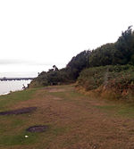
Hamble Common

Hamble Common is a Public Park, Public Common and Scheduled Monument in Hamble-le-Rice, Hampshire, not to far from Southampton. The site is 22-hectare (220,000 m2), with if formerly hosting an Iron Age settlement as well as a Tudor Castle. The Common is bounded by the Southampton Water, River Hamble and the village of Hamble. Due to the site's environmental position, the site is part of the 'Lee-on-The Solent to Itchen Estuary Site of Special Scientific Interest' due to its wide range of habitats including coastal heath, woodland, saltmarsh and mudflats, which attract a large range of birds. The area is owned and managed by Eastleigh Borough Council. The site contains Hamble Point, which is a spit formed by the River Hamble meets the Southampton Water.
Excerpt from the Wikipedia article Hamble Common (License: CC BY-SA 3.0, Authors, Images).Hamble Common
School Lane,
Geographical coordinates (GPS) Address Nearby Places Show on map
Geographical coordinates (GPS)
| Latitude | Longitude |
|---|---|
| N 50.8525 ° | E -1.3175 ° |
Address
School Lane
School Lane
SO31 4QG , Hamble-le-Rice
England, United Kingdom
Open on Google Maps


