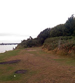
Hamble Common Camp
Archaeological sites in HampshireBuildings and structures in HampshireHampshire building and structure stubsHill forts in HampshireIron Age sites in England ... and 1 more
United Kingdom archaeology stubs

Hamble Common Camp is the site of an Iron Age promontory hillfort located in Hampshire. The fort is located on Hamble common on a peninsula of land formed between Southampton Water and the River Hamble. The site was later occupied by St Andrews castle, one of the Device Forts built by King Henry VIII.
Excerpt from the Wikipedia article Hamble Common Camp (License: CC BY-SA 3.0, Authors, Images).Hamble Common Camp
School Lane,
Geographical coordinates (GPS) Address Nearby Places Show on map
Geographical coordinates (GPS)
| Latitude | Longitude |
|---|---|
| N 50.8515 ° | E -1.3172 ° |
Address
School Lane
School Lane
SO31 4QG , Hamble-le-Rice
England, United Kingdom
Open on Google Maps


