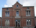
Quatre Bras
GenappePages with French IPAPopulated places in Walloon BrabantWalloon Brabant geography stubs

Quatre Bras ([kat.ʁə bʁɑ], French for crossroads; literally "four arms") is a hamlet in the municipality of Genappe, Wallonia, Belgium. It lies on the crossroad of the Charleroi–Brussels road (currently named N5) and the Nivelles–Namur road south of Genappe. On June 16, 1815, near the crossroads of Quatre Bras, the Battle of Quatre Bras (part of the Waterloo Campaign) was fought between contingents of the Anglo-Allied army and the left wing of the French Army. There are several monuments to the battle at Quatre Bras. Monuments in Quatre Bras
Excerpt from the Wikipedia article Quatre Bras (License: CC BY-SA 3.0, Authors, Images).Quatre Bras
Chaussée de Namur,
Geographical coordinates (GPS) Address Nearby Places Show on map
Geographical coordinates (GPS)
| Latitude | Longitude |
|---|---|
| N 50.571388888889 ° | E 4.4533333333333 ° |
Address
Chaussée de Namur
Chaussée de Namur
1470 (Baisy-Thy)
Walloon Brabant, Belgium
Open on Google Maps


