North Point (Cambridge, Massachusetts)
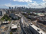
North Point is a neighborhood within the East Cambridge section of Cambridge, Massachusetts. A former railroad yard, the site was originally built by the Boston and Maine Railroad. It is triangular in shape and bound by the MBTA Commuter Rail Fitchburg Line, the Charles River and associated dam with the Lechmere Viaduct, the former Lechmere wetlands, and Millers River remnant that once divided Cambridge and Charlestown, along with the Interstate 93 Northern Expressway viaduct to the northeast. After development continued in the area surrounding, it was decided to turn portions of the now-unused rail yard area into a large development, containing commercial, retail and residential development, along with a relocated Lechmere Green Line transit station. The area was master planned and partially constructed under the name NorthPoint, from which the neighborhood received its name, though a different developer has taken over the remainder of the site from the original developer. Upon ownership transition, the new developer reimagined the original master plan envisioning a center for innovation and collaboration with a central retail hub surrounded by acres of open space. With this new vision, the new developer renamed their portion of the original site as Cambridge Crossing.
Excerpt from the Wikipedia article North Point (Cambridge, Massachusetts) (License: CC BY-SA 3.0, Authors).North Point (Cambridge, Massachusetts)
Jacobs Street, Cambridge
Geographical coordinates (GPS) Address Nearby Places Show on map
Geographical coordinates (GPS)
| Latitude | Longitude |
|---|---|
| N 42.372388888889 ° | E -71.075055555556 ° |
Address
LamplighterBrewing Co.
Jacobs Street
02214 Cambridge
Massachusetts, United States
Open on Google Maps


