place

Kharkiv (river)

Belgorod Oblast geography stubsGeography of KharkivKharkiv Oblast geography stubsRivers of Belgorod OblastRivers of Kharkiv Oblast
Russia river stubsTributaries of the DonetsUkraine river stubs
ChigirinBridge01
ChigirinBridge01

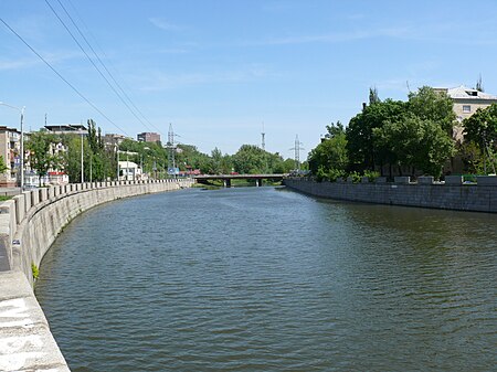
The Kharkiv or Kharkov (Ukrainian: Ха́рків, Russian: Харьков) is a river in Kharkiv Oblast, Ukraine, a left tributary of the Lopan. It originates from the town of Oktyabrsky in Belgorod Oblast, Russia and it falls into Lopan in the city of Kharkiv. The river Kharkiv may have given the city of Kharkiv its name. The river is also known as a place for people who enjoy cold-water swimming known as morzhei or "walruses" to swim.

Excerpt from the Wikipedia article Kharkiv (river) (License: CC BY-SA 3.0, Authors, Images).

Kharkiv (river)
Netechenska Embarkment, Kharkiv Москалівка

Geographical coordinates (GPS) Address Nearby Places
placeShow on map

Wikipedia: Kharkiv (river)Continue reading on Wikipedia

Geographical coordinates (GPS)

Latitude Longitude
N 49.9853 ° E 36.2239 °
placeShow on map

Address

Лопанська стрілка

Netechenska Embarkment
61012 Kharkiv, Москалівка
Kharkiv Oblast, Ukraine
mapOpen on Google Maps

ChigirinBridge01
ChigirinBridge01
Share experience

Nearby Places

Tsentralnyi Rynok (Kharkiv Metro)

The Tsentralnyi Rynok (Ukrainian: Центральний ринок, (listen); Russian: Центральный рынок) is a station on Kharkiv Metro's Kholodnohirsko–Zavodska Line. The station was opened on 23 August 1975. It is located in the central part of Kharkiv, near the №2 bus station and the Tsentralny Rynok, literally Central Market, for which the station is named. In the beginning, a station named Kommynalnyi Rynok was planned to be built in the Blagoveschenskyi Raion. But during the examining pre-construction stage, the hydro-geological circumstances proved to be too poor for the construction of the station. As a result, the station was planned to be located some way to one side. The station is lain shallow underground and is a single-vault design with a rounded ceiling. The station itself was designed by V.A. Spivachuk, and engineered by P.D Pashkov and Y.V. Lysenko. The partitions tracks have been held by grey marble, which has been introduced in traditional Ukrainian folk relief designs. The floor has been paved with multi-coloured polished granite, which is reminiscent of a carpet-like design. Wide stairs which lead passengers to a station vestibule are located on both ends of the station, which gives the station an open feeling. The walls of the vestibule are decorated with light-grey and light-rose coloured marble. The Tsentralny Rynok station is unique because it has a rounded ceiling which is held up with numerous rose marble columns. These columns were added in 1996 after serious deterioration of the ceiling caused by high levels of precipitation due to heavy rain fall in the summer of that year. However, during the column additions to the station, a task which lasted about a year, the station continued to be in full operation. Tsentralny Rynok Station is located near Dim Trohivli (a four-story department store), Avto Vokzal 2 (a bus terminal) and the Kharkiv Yeshiva Ketana (a Jewish religious school for boys).

Istorychnyi Muzei (Kharkiv Metro)

The Istorychnyi Myzei (Ukrainian: Історичний музей, (listen); literally "Historic Museum") is a station on Kharkiv Metro's Saltivska Line. The station was opened on 10 August 1984 and is currently the southwesternmost terminus of the Saltivska Line. It is located beneath the Maidan Konstytutsii, literally Constitution square in the historical part of Kharkiv, and is named for the historical museum which is located on the square. The station, inspired by the history of Kharkiv, has shaped columns and a relief-type ceiling in the station vestibule which give the feeling of the protected fort, which stood at this location during the 17th and 18th centuries. Also, the arrow-shaped arcs between the columns are reminiscent of fort gates. The columns are finished in a light colored marble Koelga and the tunnel walls are finished with brown marble and heraldic items made from bronze, which provide contrast. The Istorychniy Muzei station is located deep underground and is a pylon trivault and was designed by V.A. Spivachuk, P.G. Chechalnitskiy, and I.T. Karpenko; engineered by P.D. Pashkov, V.D. Shtuchkin, and L.P. Hryshyna; and was decorated by P.D. Chernova, V.E. Hutnik; I.I. Morgunov, O.Y. Erofeeva, V.V. Chursin, and V.D.Semenyuk. Istorychniy Muzei forms a complex with the adjacent Maidan Konstytutsii station on the Kholodnohirsko-Zavodska Line. Transfer tunnels from one station to another are located in the centre of the station. Also, four escalators lead into a spacious underground vestibule which is located under the Constitution Square. The vestibule is connected with the underground passenger tunnel which leads onto the square, to the Sums`ka Street, the largest street in Kharkiv, to the Universytets`ka Street, and to the Bursatskyi Descent. In 1985, during the finishing of the transfer tunnel from the Istorychniy Muzei to the Ploshcha Konstytutsii station, a closed-circuit television (CCTV) system was installed, the first in the Kharkiv Metro. Currently, all stations on the system have CCTV. The installation of this system allowed the workers of the metro to keep passengers in order and maintain more effective control over the escalators.

Second Battle of Kharkov

The Second Battle of Kharkov or Operation Fredericus was an Axis counter-offensive in the region around Kharkov against the Red Army Izium bridgehead offensive conducted 12–28 May 1942, on the Eastern Front during World War II. Its objective was to eliminate the Izium bridgehead over Seversky Donets or the "Barvenkovo bulge" (Russian: Барвенковский выступ) which was one of the Soviet offensive's staging areas. After a winter counter-offensive that drove German troops away from Moscow but depleted the Red Army's reserves, the Kharkov offensive was a new Soviet attempt to expand upon their strategic initiative, although it failed to secure a significant element of surprise. On 12 May 1942, Soviet forces under the command of Marshal Semyon Timoshenko launched an offensive against the German 6th Army from a salient established during the winter counter-offensive. After a promising start, the offensive was stopped on 15 May by massive airstrikes. Critical Soviet errors by several staff officers and by Joseph Stalin, who failed to accurately estimate the 6th Army's potential and overestimated their own newly raised forces, facilitated a German pincer attack on 17 May which cut off three Soviet field armies from the rest of the front by 22 May. Hemmed into a narrow area, the 250,000-strong Soviet force inside the pocket was exterminated from all sides by German armored, artillery and machine gun firepower as well as 7,700 tonnes of air-dropped bombs. After six days of encirclement, Soviet resistance ended, with the remaining troops being killed or surrendering. The battle was an overwhelming German victory, with 280,000 Soviet casualties compared to just 20,000 for the Germans and their allies. The German Army Group South pressed its advantage, encircling the Soviet 28th Army on 13 June in Operation Wilhelm and pushing back the 38th and 9th Armies on 22 June in Operation Fridericus II as preliminary operations to Case Blue, which was launched on 28 June as the main German offensive on the Eastern Front in 1942.