Ciudad Satélite

Ciudad Satélite (lit. transl. Satellite City), commonly known as Satélite, is an upper-middle and upper-class neighborhood located 14 KM northwest of Mexico City's Historic Center, in Naucalpan, in the western part of Greater Mexico City. Officially, the name corresponds exclusively to the homonym neighbourhood, Ciudad Satélite, founded circa 1957. But over time, its surrounding area—including upper-middle class neighbourhoods like Lomas Verdes, Echegaray, Paseos del Bosque or San Mateo, alongside adjacent municipalities Atizapán de Zaragoza and Tlalnepantla de Baz—has also become collectively known as "Satélite", due to its prominence as both an economically and socially dynamic area.Initially conceived as a "city outside the city", in response to the increasing population of Mexico City's upper classes, it has been one of Mexico's most prominent architectural ventures during the 20th century. Designed and built by Mexican architects Mario Pani and José Luis Cuevas Pietrasanta under the aegis of then president Miguel Alemáns' family ranch, Los Pirules, which was purchased from the Fuentes-Centurion family on the hacienda Los Chabacanos, it quickly became popular among wealthy locals who wanted to acquire property outside the city itself.
Excerpt from the Wikipedia article Ciudad Satélite (License: CC BY-SA 3.0, Authors, Images).Ciudad Satélite
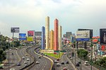
Avenida Santa Cruz del Monte, Ciudad Satélite
Geographical coordinates (GPS) Address Nearby Places Show on map
 Continue reading on Wikipedia
 Geographical coordinates (GPS)
| Latitude | Longitude |
|---|---|
| N 19.516666666667 ° | E -99.25 ° |
Address
Avenida Santa Cruz del Monte 92
53100 Ciudad Satélite
State of Mexico, Mexico
Open on Google Maps