place

Torres de Satélite

1958 sculpturesArchitecture in MexicoHistory of the State of MexicoLandscape design historyMexican building and structure stubs
Modernist architecture in MexicoTowers in Mexico
Torres de Satélite 2

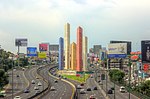
The Torres de Satélite ("Satellite Towers") are a group of sculptures located in the Ciudad Satélite district of Naucalpan, State of Mexico. One of the country's first urban sculptures of great dimensions, had its planning started in 1957 with the ideas of renowned Mexican architect Luis Barragán, painter Jesús Reyes Ferreira and sculptor Mathias Goeritz. The project was originally planned to be composed of seven towers, with the tallest one reaching a height of 200 meters (about 650 feet), but a budget reduction forced the design to be composed of only five towers, with the tallest measuring 52 meters (170 feet) and the shortest 30 meters (98 feet). Goeritz originally wanted the towers to be painted in different shades of orange, but changed his mind later due to some pressure from constructors and investors. It was finally decided that there would be one tower each in red, blue and yellow, the primary subtractive colors, and two in white. Thus, in the first days of March 1958, the Satélite Towers were inaugurated as the symbol of the newborn and modern Ciudad Satélite.

Excerpt from the Wikipedia article Torres de Satélite (License: CC BY-SA 3.0, Authors, Images).

Torres de Satélite
Boulevard Manuel Ávila Camacho, Naucalpan de Juárez

Geographical coordinates (GPS) Address Nearby Places
placeShow on map

Wikipedia: Torres de SatéliteContinue reading on Wikipedia

Geographical coordinates (GPS)

Latitude Longitude
N 19.499263888889 ° E -99.236886111111 °
placeShow on map

Address

Torres de Satétlite

Boulevard Manuel Ávila Camacho
53100 Naucalpan de Juárez
State of Mexico, Mexico
mapOpen on Google Maps

Torres de Satélite 2
Share experience

Nearby Places

Tlatilco
Tlatilco

Tlatilco was a large pre-Columbian village in the Valley of Mexico situated near the modern-day town of the same name in the Mexican Federal District. It was one of the first chiefdom centers to arise in the Valley, flourishing on the western shore of Lake Texcoco during the Middle Pre-Classic period, between the years of 1200 BCE and 200 BCE. It gives its name to the "Tlatilco culture", which also included the town of Tlapacoya, on the eastern shore of Lake Chalco. Tlatilco is noted in particular for its high quality pottery pieces, many featuring Olmec iconography, and its figurines, including Olmec-style baby-face figurines. Much else, however, seems to be in a native ceramic tradition. These Olmec-style artifacts have led to speculation concerning the nature of Olmec influence on other Mesoamerican cultures. The Tlatilco site was used in modern times as a source of clay for brick-making. By the 1930s, many of the ancient artifacts thereby uncovered made their way into the hands of collectors, including Miguel Covarrubias, artist and ethnographer. Covarrubias led the first controlled excavation in 1942. By 1949, over 200 burials were identified at Tlatilco, leading to its categorisation as a necropolis. Two major archaeological excavations followed, with over 500 burials eventually identified, many with intact grave offerings. The last field season also undertook a systematic survey of non-burial structures, leading to the realization that these hundreds of burials were apparently located under ancient houses—although no traces of them remain - as well as among the various trash pits, and that Tlatilco was not a necropolis, but rather a major chiefdom center.Many burials, primarily of high status individuals, show evidence of dental mutilation and artificial cranial deformation, most probably through the use of cradleboards. The Tlatilcans' agriculture was focused on maize, but also included beans, amaranth, and squash, and chili peppers. These plants were supplemented with various fowl, including migratory birds, wild rabbits and other smaller mammals, and deer and antelope.Tlatilco reached its heyday during the period from 1000 to 700 BCE, during the Olmec horizon. The following Zacatenco phase (700-400 BCE) saw a cessation of the use of Olmec iconography and forms.

Lomas Verdes
Lomas Verdes

Lomas Verdes is an upper-middle-class neighborhood located in the north of Mexico City. The community was developed in the late 1960s and is near Ciudad Satélite (which was founded in 1957). Lomas Verdes means "Green Hills" in Spanish, as the terrain had a set of smooth hills covered with green grass and other wild vegetation, which nowadays are totally covered with houses.The neighborhood consists of several sections: La Alteña I, II and III, La Soledad, Misiones, and the sections I, II, III, IV, V and the now in construction sección VI. To the North, Lomas Verdes borders the county of Atizapán de Zaragoza, to the south and the west with others neighborhoods of Naucalpan, and to the east with the ancient colonial town of Santa Cruz del Monte. After its foundation Lomas Verdes was a so-called "bedroom community", as the majority of the residents commutes México City (7 miles far away) for work. Today, twenty years after founding, there are a strong commercial and services sector in the zone. The most important artery serving the area is the Súper Avenida Lomas Verdes, which connects the neighborhood with the Periferico and the elevated highway that leads direct into the heart of Mexico City. As all Latin American urban developments the increasing growth of the population and the unplanned urban strategy overwhelmed the infrastructure and now traffic jams, accidents, air pollution and chaotic expansion have reduced the quality of the life of the inhabitants.

Naucalpan
Naucalpan

Naucalpan, officially Naucalpan de Juárez, is one of 125 municipalities located just northwest of Mexico City in the adjoining State of Mexico. The municipal seat is the city of Naucalpan de Juárez, which extends into the neighboring municipality of Huixquilucan. The name Naucalpan comes from Nahuatl and means "place of the four neighborhoods" or "four houses." Juárez was added to the official name in 1874 in honor of Benito Juárez. The history of the area begins with the Tlatilica who settled on the edges of the Hondo River between 1700 and 600 B.C.E., but it was the Mexica who gave it its current name when they dominated it from the 15th century until the Spanish conquest of the Mexica Empire. Naucalpan claims to be the area where Hernán Cortés rested on the "Noche Triste" as they fled Tenochtitlan in 1520, but this is disputed. It is the home of the Virgin of Los Remedios, a small image of the Virgin Mary which is strongly associated with the Conquest and is said to have been left here.Today, the city of Naucalpan is actually larger than the municipality itself, with part of it extending into neighboring Huixquilucan Municipality, although there are other towns in within the municipality of Naucalpan which are outside the city of Naucalpan. It is a major center of industry in Mexico. It is, however, best known as the location of Ciudad Satélite, a development from the 1960s and the site of the Toreo de Cuatro Caminos bullring, which was demolished in the 2010s to build the Toreo Parque Central mixed-use development. The only unurbanized areas of the municipality are the Los Remedios National Park and a number of ejidos, but the lack of housing has put serious pressure on these areas.