place

Mexico Farms Airport

Airports in MarylandTransportation buildings and structures in Allegany County, MarylandTransportation in Cumberland, MD-WV-PA

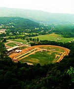
Mexico Farms Airport (FAA LID: 1W3) is a public airport located 3 miles (4.8 km) south of downtown Cumberland, Maryland, United States. The airport is located immediately south of the larger Greater Cumberland Regional Airport. Resources for this airport: FAA airport information for 1W3 AirNav airport information for 1W3 FlightAware airport information and live flight tracker SkyVector aeronautical chart for 1W3

Excerpt from the Wikipedia article Mexico Farms Airport (License: CC BY-SA 3.0, Authors).

Mexico Farms Airport
Mexico Farm Road Southeast,

Geographical coordinates (GPS) Address External links Nearby Places
placeShow on map

Wikipedia: Mexico Farms AirportContinue reading on Wikipedia

Geographical coordinates (GPS)

Latitude Longitude
N 39.604722222222 ° E -78.760555555556 °
placeShow on map

Address

Mexico Farms Airport

Mexico Farm Road Southeast
26767
Maryland, United States
mapOpen on Google Maps

linkWikiData (Q3565442)
linkOpenStreetMap (133900786)

Share experience

Nearby Places

Cumberland, MD-WV MSA

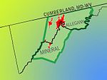
Cumberland, MD-WV MSA, or Cumberland Metro for short, is the Metropolitan Statistical Area of Cumberland, Maryland and the surrounding economic region of Allegany County, Maryland and Mineral County, West Virginia, in the United States. A Metropolitan Statistical Area represents a regional economy of closely tied cities, towns, and surrounding rural areas with a high degree of social, geographic, and economic integration; and a total combined regional population of 50,000 or more. Metro Statistical Areas are named after the primary city and states within the area. As of 2000, The City of Cumberland had a population of 21,591 and the surrounding area had a population of 102,008. Allegany and Mineral are mountainous, mostly rural areas. According to the 2000 census, more than 45 percent of the people living in the Cumberland region live in rural and non-incorporated areas. The Cumberland Metropolitan Area is geographically isolated by a range of ridges and valleys from the rest of Maryland which is relatively flat. These mountain ranges form adjacent valleys which have served to collect and integrate the regional cities and towns together into urbanized channels that follow the valleys northeasterly. This has served to give the area a unique sense of identity and economic integration. The median household income for the MSA was $30,916 and the average household income was $39,021. The Cumberland, MD-WV Metropolitan Statistical Area is one of the poorest in the United States, ranking 305th out of 318 metropolitan areas in per capita income.