Hawkesbury River

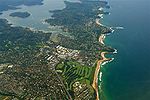
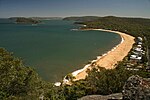
The Hawkesbury River, or Hawkesbury-Nepean River, is a river located northwest of Sydney, New South Wales, Australia. The Hawkesbury River and its associated main tributary, the Nepean River, almost encircle the metropolitan region of Sydney. The Hawkesbury River has its origin at the confluence of the Nepean River and the Grose River, to the north of Penrith and travels for approximately 120 kilometres (75 mi) in a north–easterly and then a south–easterly direction to its mouth at Broken Bay, about 15 kilometres (9.3 mi) from the Tasman Sea. The Hawkesbury River is the main tributary of Broken Bay. Secondary tributaries include Brisbane Water and Pittwater, which, together with the Hawkesbury River, flow into Broken Bay and thence into the Tasman Sea north of Barrenjoey Head. The total catchment area of the river is approximately 21,624 square kilometres (8,349 sq mi) and the area is generally administered by the Hawkesbury–Nepean Catchment Management Authority. The land adjacent to the Hawkesbury River was occupied by Aboriginal peoples: the Darkinjung, Darug, Eora, and Kuringgai. They used the river as a source of food and a place for trade. In the languages of the traditional custodians the river is Deerubben or Dyarubbin.In March 2021, the river level rose, and many areas were flooded as part of the March 2021 Australian floods.
Excerpt from the Wikipedia article Hawkesbury River (License: CC BY-SA 3.0, Authors, Images).Hawkesbury River
Central Coast Council
Geographical coordinates (GPS) Address Nearby Places Show on map
Geographical coordinates (GPS)
| Latitude | Longitude |
|---|---|
| N -33.564999833333 ° | E 151.3 ° |
Address
Patonga
2256 Central Coast Council, Patonga
New South Wales, Australia
Open on Google Maps


