Fleam Dyke
Ancient dikesAnglo-Saxon sites in EnglandArchaeological sites in CambridgeshireBronze Age sites in CambridgeshireHistory of Cambridgeshire ... and 3 more
Linear earthworksScheduled monuments in CambridgeshireSites of Special Scientific Interest in Cambridgeshire

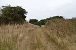
Fleam Dyke is a linear earthwork between Fulbourn and Balsham in Cambridgeshire, initiated at some timepoint between AD 330 and AD 510. It is three miles long and seven metres high from ditch to bank, and its ditch faces westwards, implying invading Saxons as its architects. Later, it formed a boundary of the late Anglo-Saxon administrative division of Flendish Hundred. At a prominent point, the earthwork runs beside Mutlow Hill, crowned by a 4000-year-old Bronze Age burial mound. The entire length is now a Scheduled Monument and a 7.8-hectare (19-acre) biological Site of Special Scientific Interest.
Excerpt from the Wikipedia article Fleam Dyke (License: CC BY-SA 3.0, Authors, Images).Fleam Dyke
Fleam Dyke, Cambridgeshire
Geographical coordinates (GPS) Address External links Nearby Places Show on map
Geographical coordinates (GPS)
| Latitude | Longitude |
|---|---|
| N 52.16 ° | E 0.266 ° |
Address
Fleam Dyke
Fleam Dyke
CB21 4HQ Cambridgeshire (South Cambridgeshire)
England, United Kingdom
Open on Google Maps


