place

Thameside Promenade

Berkshire geography stubsParks and open spaces in Reading, Berkshire
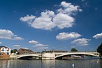
Thames Side Promenade geograph.org.uk 2606364

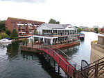
Thameside Promenade, or Thames Side Promenade, is a public park and promenade in Reading, Berkshire, England, located next to the River Thames. It stretches along the south (Reading) side of the river, to the west of Caversham Bridge, and forms part of the Thames Path long distance footpath. The park includes grassland behind the promenade.Thameside Promenade form part of a series of riverside open spaces, managed by Reading Borough Council, that stretch along one or other side of the River Thames throughout its passage through Reading. From west to east these are Thameside Promenade, Caversham Court, Christchurch Meadows, Hills Meadow, View Island and King's Meadow.The principle access to Thameside Promenade is from the eastern (Caversham Bridge) end, where there is a car park and Reading Rowing Club have their boathouse. A little further along, access is possible from Rivermeade Leisure Centre, which occupies a site on the grassland behind the promenade. About half-way along the promenade it is intersected by Cow Lane, and beyond that point the farmland behind the promenade is used as part of the Reading Festival site. In contrast to the relatively flat land on the promenade side of the river, the land on the opposite bank rises steeply into Caversham Heights, and the path provides good views of the up-market riverside housing along the Warren and the hills behind.

Excerpt from the Wikipedia article Thameside Promenade (License: CC BY-SA 3.0, Authors, Images).

Thameside Promenade
The Warren, Reading Caversham Heights

Geographical coordinates (GPS) Address Nearby Places
placeShow on map

Wikipedia: Thameside PromenadeContinue reading on Wikipedia

Geographical coordinates (GPS)

Latitude Longitude
N 51.4677 ° E -0.9872 °
placeShow on map

Address

The Warren
RG4 7TH Reading, Caversham Heights
England, United Kingdom
mapOpen on Google Maps

Thames Side Promenade geograph.org.uk 2606364
Share experience

Nearby Places

Caversham Heights (Reading ward)

Caversham Heights is an electoral ward of the Borough of Reading, in the English county of Berkshire. The ward was created by a boundary reorganisation prior to the 2022 Reading Borough Council election, and has replaced the Mapledurham ward, with the addition of parts of the old Thames and Peppard wards. During the reorganisation process, the ward was known as The Heights, but the name was subsequent changed as a result of public consultation.The ward lies in Caversham, once a separate town to the north of the River Thames, and includes the area known as Caversham Heights, together with other parts of the larger area of Caversham. From the south in clockwise order it is bounded by the River Thames, the borough boundary to the west and north, Highdown Hill Road, St Barnabas Road, Evesham Road, Rotherfield Way, Oakley Road, Kidmore Road, The Mount, and The Warren back to the River Thames. The ward is bordered, in the same order, by Mapledurham and Kidmore End civil parishes of Oxfordshire, followed by Emmer Green, Caversham, new Thames, Battle, and Kentwood wards. It is entirely within the Reading East parliamentary constituency.As with all Reading wards, the ward elects three councillors to Reading Borough Council. Elections since 2004 are generally held by thirds, with elections in three years out of four, although the 2022 elections were for all councillors due to the boundary changes. The ward councillors are currently Isobel Ballsdon and Paul Carnell, both members of the Conservative party, and Sue Kitchingham, of the Labour party.

Caversham Bridge
Caversham Bridge

Caversham Bridge is a bridge across the River Thames between Caversham and the town centre of Reading. The bridge is situated on the reach above Caversham Lock, carrying the A4155 road across the river and also providing pedestrian access to the adjacent mid-river Pipers Island. The first bridge on the site was built sometime between 1163, when a famous trial by combat was fought on nearby De Montfort Island, and 1231, when Henry III wrote to the Sheriff of Oxfordshire, commanding him: "to go in person, taking with him good and lawful men of his county, to the chapel of St Anne on the bridge at Reading over the Thames one side of which is built on the fee of William Earl Marshal and by the view and testimony of those men see that the abbot has the same seisin of the said chapel as he had on the day the said earl died."William Marshal was the first Earl of Pembroke, the principal landowner in the Caversham area, and regent during the early years of Henry's reign. He had died at his home at Caversham Park in 1218. The old bridge was the site of a skirmish during the English Civil War in 1643 and was left with a wooden drawbridge structure on the Berkshire half. The bridge was still in this state when it was depicted by Joseph Mallord William Turner in 1806/7, in a painting entitled Caversham Bridge with Cattle in the Water.In 1869, the entire bridge was replaced by an iron lattice construction. When Reading Bridge was completed in 1923 work began on replacing Caversham Bridge with the current structure which is of concrete with a granite balustrade. It was opened in 1926 by Edward Prince of Wales.