place

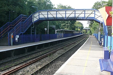
Reading West railway station

Buildings and structures in Reading, BerkshireDfT Category E stationsFormer Great Western Railway stationsRailway stations in BerkshireRailway stations in Great Britain opened in 1906
Railway stations served by Great Western RailwayTransport in Reading, BerkshireUse British English from May 2012
Reading West railway station

Reading West railway station serves West Reading, Berkshire, about 1 mile (1.6 km) west from the town's main retail and commercial areas. The station is served by local services operated by Great Western Railway. It is 36 miles 75 chains (36.94 mi; 59.4 km) down the line the zero point at London Paddington.

Excerpt from the Wikipedia article Reading West railway station (License: CC BY-SA 3.0, Authors, Images).

Reading West railway station
Oxford Road, Reading Reading West

Geographical coordinates (GPS) Address Nearby Places
placeShow on map

Wikipedia: Reading West railway stationContinue reading on Wikipedia

Geographical coordinates (GPS)

Latitude Longitude
N 51.455142 ° E -0.990516 °
placeShow on map

Address

Oxford Road 291
RG30 1AS Reading, Reading West
England, United Kingdom
mapOpen on Google Maps

Reading West railway station
Share experience

Nearby Places

All Saints' Church, Reading

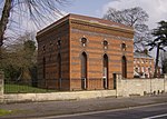
All Saints' Church is a Church of England parish church in the town of Reading in the English county of Berkshire. The church is on Downshire Square, a tree-lined square in West Reading close to the Bath Road. It is part of the parish of St. Mark and All Saints, which includes St. Mark's Church. The church was built between 1865 and 1874, as a daughter church of the Minster Church of St Mary, to serve the growing population of the Bath Road area. It was designed by the architect James Piers St Aubyn. The construction is of coursed rubble with ashlar dressings and weathered buttresses. The roof is tiled, and the church has a five bay aisled nave with a short transept. The interior includes a painted arcade, a rich five-window apse, and mural mosaics, the finest of which is a glass mosaic reredos depicting the last supper. This came from the London workshop of the renowned glass artist Antonio Salviati and was installed in 1866. The foundations for a tower to the south side of the church were constructed, but the tower itself was never completed.The music for the church was originally provided by a small four-stop organ lent to the church by a "Father Willis", which was positioned in the original North transept. The organ was extensively enhanced to include a triple keyboard and additional pipes between 1874 and 1883, and has remained in more or less the same form until the present day.There is a current project appeal for the upgrading of the church to modern accessibility standards. This project hopes to add toilet facilities and improve disabled access to the building whilst retaining the church's unique character and architectural features.The church is categorised as a Grade II listed building by English Heritage.

Coley (Reading ward)

Coley is an electoral ward of the Borough of Reading, in the English county of Berkshire. Until the 2022 Reading Borough Council election, it was known as Minster ward and had slightly different boundaries. It lies south-west of the town centre, comprising all or parts of the suburbs of Coley, Coley Park, and West Reading, together with a large tract of undeveloped River Kennet flood-plain to the south. From the south in clockwise order it is bounded by the River Kennet, the Reading to Basingstoke railway line, Reading West railway station, the Oxford Road, Prospect Street, Tilehust Road, Castle Hill, and the A33 back to the River Kennet. The ward is bordered, in the same order, by Whitley, Southcote, Battle, Abbey and Katesgrove wards. It lies entirely within the Reading West parliamentary constituency.The principal changes to the ward boundary in 2022 were the loss of the section of the old Minster ward to the west of the railway line, bounded by Bath Road, Parkside Road and Tilehurst Road, to Southcote ward, and the loss of the strip of Minster ward to the east of the A33, as far as the River Kennet, to Katesgrove ward. Coley ward also gained the area bounded by Tilehurst Road, Reading West station, Oxford Road and Prospect Street from Battle ward.As of 2016, there were just over 10,000 people living in Minster ward, of whom 21% were aged under 16, 12.6% were aged 65 and over, and 29% were born outside the UK. The population lived in a total of just under 4,700 dwellings, of which almost 50% were in purpose-built blocks of flats, and around 20% each were terraced houses or semi-detached houses, with detached houses and flat conversions making up the rest. Of the population aged between 16 and 74, approximately 70% were in employment and 5.5% were unemployed. Of those in employment, 50% were in managerial, professional or technical occupations, with 26% in professional occupations.As with all Reading wards, the ward elects three councillors to Reading Borough Council. Elections since 2004 are generally held by thirds, with elections in three years out of four, although the 2022 elections were for all councillors due to the boundary changes. The ward councillors are currently Ellie Emberson, Paul Gittings and Liz Terry, all of whom are members of the Labour party.