place

Armadale railway station, Melbourne

Railway stations in Australia opened in 1879Railway stations in MelbourneUse Australian English from February 2015
Armadale Railway Station

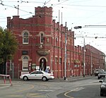
Armadale railway station is located on the Frankston line in Victoria, Australia. It serves the south-eastern Melbourne suburb of Armadale, and it opened on 7 May 1879.The station, like the suburb itself, was named after Armadale House, the residence of former premier and attorney-general James Munro. The house was named after Armadale, Scotland, where Munro was born.The station was completely rebuilt when the line to Caulfield was re-graded in the early 20th century. The work included the quadruplication of the line, allowing stopping and express trains to run simultaneously.In 1978, a former goods siding and associated point work were booked out of use. A crossover was also removed around that time.

Excerpt from the Wikipedia article Armadale railway station, Melbourne (License: CC BY-SA 3.0, Authors, Images).

Armadale railway station, Melbourne
Fetherston Street, Melbourne Armadale

Geographical coordinates (GPS) Address Website External links Nearby Places
placeShow on map

Wikipedia: Armadale railway station, MelbourneContinue reading on Wikipedia

Geographical coordinates (GPS)

Latitude Longitude
N -37.8563 ° E 145.0193 °
placeShow on map

Address

Platforms 2 & 3

Fetherston Street
3143 Melbourne, Armadale
Victoria, Australia
mapOpen on Google Maps

Website
ptv.vic.gov.au

linkVisit website

linkWikiData (Q4792530)
linkOpenStreetMap (227657650)

Armadale Railway Station
Share experience

Nearby Places

Toorak Park
Toorak Park

Toorak Park is a cricket and Australian rules football arena in the Melbourne suburb of Armadale, Victoria, Australia. It is the home ground of the Prahran Football Club and Old Xaverians Football Club of the Victorian Amateur Football Association (VAFA) and Prahran Cricket Club, which plays in the Victorian Premier Cricket competition. The current capacity of the venue is 7,000. Toorak Park opened in 1893 when it was used by Hawksburn Cricket Club (later Prahran). The Prahran Football Club in the Victorian Football Association began home matches at the venue in 1899, and used it as its home base until it left the Association after 1994. Old Xaverians moved there for the 1995 VAFA season and now share the oval with Prahran, which now also plays in the VAFA. Toorak Park hosted four VFA Grand Finals between 1935 and 1938, and served as the finals venue (including Grand Finals) for the VFA Division 2 from 1961 until 1984, except in 1967. The ground record attendance for a football match is approximately 17,000, for the 1938 VFA Grand Final between Brunswick and Brighton.During World War II, several venues used by the Victorian Football League teams were commandeered for military use. The VFA was in recess during World War II, so the St Kilda Football Club, whose Junction Oval was one of the commandeered venues, temporarily moved to Toorak Park, using it as a home base in 1942 and 1943. South Melbourne also played one home match there in 1942. Altogether, Toorak Park hosted thirteen VFL matches. The highest attendance recorded for a VFL match was 11,000 at the St Kilda vs Richmond match, round 3 of 1943. In 1959, the Prahran Council leased the ground to the Victorian Rugby Union on alternate Saturdays (when the Prahran Football Club firsts team was playing away) for the considerable sum at the time of £660, the Prahran Football Club paid only £60 to rent the ground for the whole winter. The VFA rules required that all clubs have access to the same ground throughout the winter, so that the seconds could play home when the firsts played away; as a result, Prahran was expelled from the VFA for that season. The football club secured a winter-long lease in 1960 and returned to the association.

City of Stonnington
City of Stonnington

The City of Stonnington is a local government area located within the metropolitan area of Melbourne, Australia. It comprises the inner south-eastern suburbs, between 3 and 13 km (2 and 8 mi), from the Melbourne CBD. The city covers an area of 25.7 km2 (9.9 sq mi).Within twenty years of the settlement of Melbourne in 1835, the Prahran Municipality (later City of Prahran) was formed in 1855, followed by the Gardiner Road Board (later City of Malvern) in 1856.The late 19th century saw substantial residential and commercial development such that by 1891 Prahran had a population of almost 40,000 and Malvern 11,000. Following the election of the Kennett government in the Spring of 1992, as part of a comprehensive reorganisation of local government in Victoria, the Cities of Malvern and Prahran were amalgamated to form the City of Stonnington. The logo of the City of Stonnington features two interlocking celebratory ribbons representing the coming together of the two former cities of Malvern and Prahran.Following the amalgamation of the cities the Malvern Town Hall was renamed the Stonnington City Centre and it became the corporate headquarters of the new Stonnington City Council. In 2015, the new Stonnington City Centre, opposite at 311 Glenferrie Road, was opened and the Malvern Town Hall reverted to its original name. The name Stonnington comes from Stonington mansion, the Charles D'Ebro-designed mansion built in 1890 for a founding partner of Cobb & Co, John Wagner, who named the house after his wife's birthplace in Stonington, Connecticut, USA. The house is located in Glenferrie Road, Malvern.The City of Stonnington had a population of 116,207 in June 2018.The City of Stonnington is the richest local government area in Victoria.