place

Lauriston Girls' School

1901 establishments in AustraliaEducational institutions established in 1901EngvarB from June 2018Girls' schools in Victoria (Australia)Girls Sport Victoria
International Baccalaureate schools in AustraliaJunior School Heads Association of Australia Member SchoolsNondenominational Christian schools in Melbourne

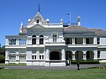
Lauriston Girls' School is an independent, non-denominational, day school for girls, located in Armadale, an inner south-eastern suburb of Melbourne, Victoria, Australia. The school follows the motto; Sancte, Sapienter, Strenue. This motto is Latin for Holiness, Wisdom, Strength. Established in 1901, Lauriston has a non-selective enrolment policy and is co-educational for three-year-old and four-year-old Kindergarten, and girls-only from Prep through to Year 12. The school currently caters for approximately 1040 students and offers the Victorian Certificate of Education (VCE) and is also one of the few Victorian schools that offer the International Baccalaureate (IB) for the Year 11/12 students. Lauriston is affiliated with the Association of Heads of Independent Schools of Australia (AHISA), the Junior School Heads Association of Australia (JSHAA), the Alliance of Girls' Schools Australasia (AGSA), the Association of Independent Schools of Victoria (AISV), and is a founding member of Girls Sport Victoria (GSV).

Excerpt from the Wikipedia article Lauriston Girls' School (License: CC BY-SA 3.0, Authors).

Lauriston Girls' School
Huntingtower Road, Melbourne Armadale

Geographical coordinates (GPS) Address Phone number Website External links Nearby Places
placeShow on map

Wikipedia: Lauriston Girls' SchoolContinue reading on Wikipedia

Geographical coordinates (GPS)

Latitude Longitude
N -37.851666666667 ° E 145.02555555556 °
placeShow on map

Address

Lauriston Girls' School

Huntingtower Road 38
3143 Melbourne, Armadale
Victoria, Australia
mapOpen on Google Maps

Phone number

call+61398647555

Website
lauriston.vic.edu.au

linkVisit website

linkWikiData (Q6501860)
linkOpenStreetMap (85542345)

Share experience

Nearby Places

City of Stonnington
City of Stonnington

The City of Stonnington is a local government area located within the metropolitan area of Melbourne, Australia. It comprises the inner south-eastern suburbs, between 3 and 13 km (2 and 8 mi), from the Melbourne CBD. The city covers an area of 25.7 km2 (9.9 sq mi).Within twenty years of the settlement of Melbourne in 1835, the Prahran Municipality (later City of Prahran) was formed in 1855, followed by the Gardiner Road Board (later City of Malvern) in 1856.The late 19th century saw substantial residential and commercial development such that by 1891 Prahran had a population of almost 40,000 and Malvern 11,000. Following the election of the Kennett government in the Spring of 1992, as part of a comprehensive reorganisation of local government in Victoria, the Cities of Malvern and Prahran were amalgamated to form the City of Stonnington. The logo of the City of Stonnington features two interlocking celebratory ribbons representing the coming together of the two former cities of Malvern and Prahran.Following the amalgamation of the cities the Malvern Town Hall was renamed the Stonnington City Centre and it became the corporate headquarters of the new Stonnington City Council. In 2015, the new Stonnington City Centre, opposite at 311 Glenferrie Road, was opened and the Malvern Town Hall reverted to its original name. The name Stonnington comes from Stonington mansion, the Charles D'Ebro-designed mansion built in 1890 for a founding partner of Cobb & Co, John Wagner, who named the house after his wife's birthplace in Stonington, Connecticut, USA. The house is located in Glenferrie Road, Malvern.The City of Stonnington had a population of 116,207 in June 2018.The City of Stonnington is the richest local government area in Victoria.