Chalgrove Airfield

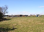
Chalgrove Airfield (ICAO: EGLJ) is a former Second World War airfield in Oxfordshire, England. It is approximately 3 mi (4.8 km) north-northeast of Benson in the heart of South Oxfordshire between Henley and Oxford; about 42 mi (68 km) north-northwest of London. Opened in 1943, it was used by both the Royal Air Force and United States Army Air Forces. During the war, it was used primarily as a combat reconnaissance airfield. It was closed in late 1946. Today, the airfield is primarily used by the Martin-Baker company for testing ejection seats. It was announced on 6 September 2016 that Chalgrove Airfield had been the subject of a ministerial transfer from the MoD to the Homes and Communities Agency (now called Homes England), with a view to building a housing-led mixed-use development on part of the airfield as part of the South Oxfordshire District Council's Local Plan 2034. This is subject to review and consultation, with the examination-in-public starting in July 2020. Homes England submitted an outline planning application on 19 June 2020 for 3,000 homes, a secondary and two primary schools, a new town centre and 40,000 square metres of employment space, along with community and leisure uses which will be determined by South Oxfordshire District Council.
Excerpt from the Wikipedia article Chalgrove Airfield (License: CC BY-SA 3.0, Authors, Images).Chalgrove Airfield
Adeane Road, South Oxfordshire Chalgrove
Geographical coordinates (GPS) Address External links Nearby Places Show on map
Geographical coordinates (GPS)
| Latitude | Longitude |
|---|---|
| N 51.674444444444 ° | E -1.0852777777778 ° |
Address
Chalgrove Airfield
Adeane Road
OX44 7RJ South Oxfordshire, Chalgrove
England, United Kingdom
Open on Google Maps


