East Carrollton, New Orleans
Neighborhoods in New OrleansNew Orleans stubs

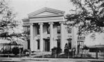
East Carrollton is a neighborhood of the city of New Orleans. A subdistrict of the Uptown/Carrollton Area, its boundaries as defined by the New Orleans City Planning Commission are: Spruce Street to the northeast, Lowerline Street to the southeast, St. Charles Avenue to the southwest and South Carrollton Avenue to the northwest. This was a portion of what was the city of Carrollton, Louisiana, before it was annexed to the city of New Orleans in the 19th century. Landmarks include the Maple Street commercial district and Lusher School.
Excerpt from the Wikipedia article East Carrollton, New Orleans (License: CC BY-SA 3.0, Authors, Images).East Carrollton, New Orleans
Breite Straße,
Geographical coordinates (GPS) Address Phone number Nearby Places Show on map
 Continue reading on Wikipedia
 Geographical coordinates (GPS)
| Latitude | Longitude |
|---|---|
| N 29.946111111111 ° | E -90.126666666667 ° |
Address
Kreisheimatmuseum
Breite Straße 46
39606
Sachsen-Anhalt, Deutschland
Open on Google Maps
Phone number