place

San Teodoro, Sardinia

Cities and towns in SardiniaMunicipalities of the Province of Sassari
Sardinia Cala Brandinchi

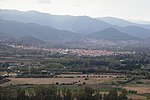
San Teodoro (Gallurese: Santu Diadòru, Sardinian: Santu Tiadòru) is a comune (municipality) in the Province of Sassari in the Italian region Sardinia, located about 180 kilometres (110 mi) northeast of Cagliari and about 20 kilometres (12 mi) southeast of Olbia. As of 31 December 2004, it had a population of 3,565 and an area of 104.8 square kilometres (40.5 sq mi).The municipality of San Teodoro contains several frazioni (subdivisions, mainly villages and hamlets), among which: La Suarédda, Monti Pitrosu, Straula, Budditogliu, La Traversa, Lu Fraili, and Lu Sitagliacciu. San Teodoro borders the following municipalities: Budoni, Loiri Porto San Paolo, Padru, Torpè. The beach of "La Cinta" was home of the kite boarding festival in September 2010. The beach of "Lu Impostu" is also known as Little Tahiti due to the beautiful colours of the sea.

Excerpt from the Wikipedia article San Teodoro, Sardinia (License: CC BY-SA 3.0, Authors, Images).

San Teodoro, Sardinia
Via Rinaggiu,

Geographical coordinates (GPS) Address Nearby Places
placeShow on map

Wikipedia: San Teodoro, SardiniaContinue reading on Wikipedia

Geographical coordinates (GPS)

Latitude Longitude
N 40.766666666667 ° E 9.6666666666667 °
placeShow on map

Address

Via Rinaggiu 79
08020
Sardinia, Italy
mapOpen on Google Maps

Sardinia Cala Brandinchi
Share experience

Nearby Places

Tavolara Island
Tavolara Island

Tavolara is a small island off the northeast coast of Sardinia, Italy. The island is a limestone massif 5 kilometres (3 miles) long and 1 kilometre (0.6 miles) wide, with steep cliffs except at its ends. Its highest point, Monte Cannone, is 565 metres (1,854 feet) above sea level. A cove and beach can be found at each end of the island, Spalmatore di Fuori at the northeast, and Spalmatore di Terra at the southwest. Currently, the island is inhabited by only a handful of families, and has a small cemetery and summer restaurant. The water around the island is a popular spot for scuba diving. The nearest sizable town is Olbia, and the small fishing village of Porto San Paolo is directly across a small strait. The islands of Molara and Molarotto are nearby. Most of the population of the island was displaced in 1962 when a NATO radiogoniometric station was constructed on the eastern half of the island. The aerials from the station can be seen from quite a distance, and that entire half of the island is restricted to military personnel. Tavolara is also home of the VLF-transmitter ICV, which works on 20.27 kHz and 20.76 kHz and which is used for transmitting messages to submarines. It can also be received (but not decoded) by PCs with a coil antenna at the soundcard entrance and FFT-analysis software. The island and the surrounding waters are part of the Tavolara and Punta Coda Cavallo Marine Preserve created in 1997. The environmental protections placed on the park have added restrictions to the use of the area for tourism. A natural column of rock on the island's coast resembles a human figure and is known as "the Stone Sentry" or "Pope's Rock." Other stone formations include "Ulysses' Bow" (a natural arch) and the "Grotta del Papa" (a cave accessible by sea and boasting Neolithic cave paintings).

San Giovanni di Posada

San Giovanni di Posada (Latin: Portus Luguidonis or Portus Liquidonis) is a frazione and small village in Sardinia, Italy, on the Tyrrhenian coast of the island, in the territory of the comune of Posada. Formerly known as Marina di Posada, it underwent rebuilding in the 1970s as an residential village for tourism. Its history goes back to the Roman harbour (named "Portus Luguidonis" - presumably located in the little bay in front of the ancient church of St. John), from where the Romans entered inner Sardinia. Through this harbour passed all the goods to or from Rome, but all the cargo was carried by small and light ships directed to Olbia (some 50km north), where bigger ships would have trafficked with Ostia. Traffic was supposedly intense, Sardinia bearing the sobriquet "the granary of Rome". In the immediate surroundings, it is supposed there was a temple in honour of Feronia, an Etruscan deity, goddess of the waters; this would prove the presence of Etruscans in this area at the time of Nuragici people. A similar cult of Feronia is reported on the Italian mainland at least in two places: in Fiano Romano (near Rome), and in Terracina, some 120km south of Rome. It is one of the main tourist destinations of Sardinia, has a long beach (more than 15km of white sand) and a system of rivers of biological importance. A part of this territory is going to be formally protected in the near future with the creation of a nature park (Parco Fluviale).