Finns Point
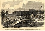
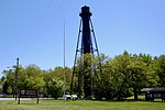
Finns Point is a small promontory in Pennsville Township, Salem County, New Jersey, and New Castle County, Delaware, located at the southwest corner of the cape of Penns Neck, on the east bank of the Delaware River near its mouth on Delaware Bay. Due to the wording of the original charter defining the boundaries of New Jersey and Delaware, part of the promontory is actually enclosed within the state of Delaware's border, due to tidal flow and the manner in which the borders between New Jersey and Delaware were first laid out. Therefore, this portion of Finns Point, also called The Baja, is an exclave of Delaware, cut off from the rest of the state by Delaware Bay. The area is about 10 miles (16 km) south of the city of Wilmington, and directly across the Delaware River from the New Castle area, and the Delaware River entrance to the Chesapeake & Delaware Canal. Pea Patch Island, part of the state of Delaware, sits in the channel of the river facing the promontory. The area in Delaware was previously protected as Killcohook National Wildlife Refuge but is now a confined disposal facility used by the U.S. Army Corps of Engineers.
Excerpt from the Wikipedia article Finns Point (License: CC BY-SA 3.0, Authors).Finns Point
Issac Drive,
Geographical coordinates (GPS) Address Nearby Places Show on map
Geographical coordinates (GPS)
| Latitude | Longitude |
|---|---|
| N 39.605833333333 ° | E -75.560555555556 ° |
Address
Issac Drive
08079
New Jersey, United States
Open on Google Maps


