place

St. Rosalia Church (Brooklyn)

1902 establishments in New York City20th-century Roman Catholic church buildings in the United StatesChristian organizations established in 1902Former Roman Catholic church buildings in New York CityItalian-American Roman Catholic national parishes in the United States
Italian-American culture in New York CityReligious organizations disestablished in 2016Roman Catholic churches completed in 1905Roman Catholic churches in Brooklyn

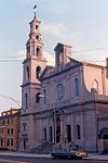
The Church of St. Rosalia (Italian: Chiesa Cattolica Italiana Romana di St. Rosalia) was a parish church in the Borough Park neighborhood of Brooklyn, New York. The parish was founded to serve the needs of Italian Catholics in the area by the then-Bishop of Brooklyn, Charles McDonnell, in 1902. It was placed under the patronage of Saint Rosalia, the patron saint of Palermo, Italy, a region from which many of the Italian-born parishioners hailed. The founding pastor was P. Sapienza, who conducted the first Masses in a converted three-story clapboard house on 62nd Street near 13th Avenue. Within a few years, a small permanent church was constructed to serve the congregation. The parish came to be considered the "Mother Church of Italian immigrants" of the diocese.In 1923 Angelo Raffaelle Cioffi (born 1887), a native of Cervinara in the Italian Province of Avellino, who had emigrated to the United States in 1907 as a seminarian, was appointed pastor of the parish by Thomas Edmund Molloy, then Bishop of Brooklyn. He stayed in the parish until his death in 1979.In 1972, the parish obtained an organ built in 1928 by the Skinner Organ Company, which had originally served a Congregational church in Connecticut.

Excerpt from the Wikipedia article St. Rosalia Church (Brooklyn) (License: CC BY-SA 3.0, Authors).

St. Rosalia Church (Brooklyn)
66th Street, New York Brooklyn

Geographical coordinates (GPS) Address Nearby Places
placeShow on map

Wikipedia: St. Rosalia Church (Brooklyn)Continue reading on Wikipedia

Geographical coordinates (GPS)

Latitude Longitude
N 40.626666666667 ° E -74.003611111111 °
placeShow on map

Address

Virginia Reginae School

66th Street 1221
11219 New York, Brooklyn
New York, United States
mapOpen on Google Maps

Share experience

Nearby Places

Dyker Heights, Brooklyn

Dyker Heights is a predominantly residential neighborhood in the southwest corner of the borough of Brooklyn in New York City. It is on a hill between Bay Ridge, Bensonhurst, Borough Park, and Gravesend Bay. The neighborhood is bounded by 7th and 14th Avenues, 65th Street, and the Belt Parkway on the west, east, north, and south, respectively. Dyker Heights originated as a speculative luxury housing development in October 1895 when Walter Loveridge Johnson developed a portion of woodland into a suburban community. It maintained its status as a wealthy neighborhood through the 20th century. During the height of his development, the boundaries were primarily between Tenth and Thirteenth Avenues and from 79th Street to 86th Street. The finest homes of the development were situated along the top of the 110-foot (34 m) hill, at about Eleventh Avenue and 82nd Street. Dyker Heights has a suburban character with detached and semi-detached one-and two-family homes, many of which have driveways and private yards, which are uncommon in parts of New York City. The neighborhood contains tree-lined streets, and there are very few apartment buildings. Dyker Heights can be divided in roughly three sections. The southernmost section, south of 86th Street and east of 7th Avenue, contains Dyker Beach Park and Golf Course. The central section between Bay Ridge Parkway and 86th Street, and between 14th Avenue and Fort Hamilton Parkway, is more exclusive in character. The northern border of the neighborhood is more closely integrated with surrounding areas. The Dyker Heights Civic Association, founded in 1928, is a civic group that represents the community's interests. The area as a whole is known for its Christmas lighting displays, which are often elaborate.Dyker Heights is part of Brooklyn Community District 10, and its primary ZIP Code is 11228. It is patrolled by the 68th Precinct of the New York City Police Department. Politically it is represented by the New York City Council's 43rd District.

Lieutenant Joseph Petrosino Park

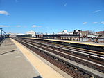
Lieutenant Joseph Petrosino Park is a New York City public park located in Bensonhurst, Brooklyn, New York City between 70th Street to the north, 71st Street to the south, 16th Avenue to the east, and New Utrecht Avenue to the west. It is on the east side of the 71st Street subway station (D train). This part of Bensonhurst was within the Town of Nieuw Utrecht when it was founded during the Dutch colonial era in 1657. The town had its name Anglicized to New Utrecht during the English colonial era. The town lost its autonomous status and became part of the City of Brooklyn in 1894. Since 16th Avenue and New Utrecht Avenue do not run parallel to each other, the footprint of the park is trapezoidal in shape.The land for the park was purchased by the City of New York in 1929, and the park was opened on May 24, 1935. It was originally called Satellite Park. When it opened, the park had handball courts, slides, swings, a wading pool, jungle gym, and a recreation building around its perimeter. A basketball court was later added on the southern side of the park extending from east to west. In 1993, the park underwent a $700,000 reconstruction. The handball courts, basketball court, and children's playground were renovated. The city installed new benches, fencing, lights and landscaping and improved the drainage. In 1999, the New York City Council renamed the park after Lt. Joseph Petrosino, NYPD.It features: Basketball court Handball courts Children's playground Spray showers

Chinatowns in Brooklyn

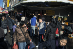
The first Brooklyn Chinatown (simplified Chinese: 布鲁克林华埠; traditional Chinese: 布魯克林華埠; pinyin: bùlǔkèlín huábù), was originally established in the Sunset Park area of the New York City borough of Brooklyn. It is one of the largest and fastest growing ethnic Chinese enclaves outside of Asia, as well as within New York City itself. As this Chinatown is rapidly evolving into an enclave predominantly of Fuzhou immigrants from Fujian Province in China, it is now increasingly common to refer to it as the Little Fuzhou or Fuzhou Town of the Western Hemisphere; as well as the largest Fuzhou enclave of New York City. Brooklyn's Chinese population has grown larger than the original Chinatown area, forming three larger Chinatowns between Sunset Park, Bensonhurst, and Avenue U in Sheepshead Bay. While the foreign-born Chinese population in New York City jumped 35 percent between 2000 and 2013, to 353,000 from about 262,000, the foreign-born Chinese population in Brooklyn increased from 86,000 to 128,000. The newer Brooklyn Chinatowns that evolved are mostly Cantonese speaking and therefore they are sometimes regarded as a Little Hong Kong/Guangdong or Cantonese Town.The 2020 census data from New York City Department of City Planning indicated that Bensonhurst had Brooklyn's largest number of Asian residents, with 46,000, with Central Sunset Park containing 31,400 Asian residents. The Asian population in southern Brooklyn is primarily Chinese-speaking.