Beaufort Island (Hong Kong)
Hong Kong geography stubsIslands of Hong KongPo Toi IslandsUninhabited islands of Hong KongUse British English from September 2016

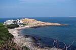
Beaufort Island is a member of the Po Toi group of islands in Hong Kong. Its size is about 120 ha (300 acres) while its highest point is 270 m (890 ft) above sea level. The channel next to Beaufort Island called Lo Chau Mun, or Beaufort Channel, is the deepest part of Hong Kong at 66 m (217 ft) below sea level.
Excerpt from the Wikipedia article Beaufort Island (Hong Kong) (License: CC BY-SA 3.0, Authors, Images).Beaufort Island (Hong Kong)
Islands District
Geographical coordinates (GPS) Address Nearby Places Show on map
 Continue reading on Wikipedia
 Geographical coordinates (GPS)
| Latitude | Longitude |
|---|---|
| N 22.183333 ° | E 114.25 ° |
Address
離島區 Islands District
Islands District
Hong Kong, China
Open on Google Maps