Kau Pei Chau
Hong Kong Island geography stubsIslands of Hong KongSouthern District, Hong KongUse Hong Kong English from August 2020

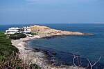
Kau Pei Chau is an uninhabited islet located off the coast of Hong Kong Island, about 50 metres off the tip of Cape D'Aguilar. Administratively, it is part of Southern District. Kau Pei Chau has a length of 1.34 kilometres (0.83 mi). It is located directly south of the Cape D’Aguilar Marine Reserve.
Excerpt from the Wikipedia article Kau Pei Chau (License: CC BY-SA 3.0, Authors, Images).Kau Pei Chau
Hong Kong Island
Geographical coordinates (GPS) Address Nearby Places Show on map
 Continue reading on Wikipedia
 Geographical coordinates (GPS)
| Latitude | Longitude |
|---|---|
| N 22.2 ° | E 114.25 ° |
Address
芽菜坑村 Nga Choy Hang Tsuen
Hong Kong Island (Southern District)
Hong Kong, China
Open on Google Maps