place

Northampton

Civil parishes in NorthamptonshireCounty towns in EnglandFormer boroughs in EnglandFormer non-metropolitan districts of NorthamptonshireHarv and Sfn no-target errors
Incomplete lists from July 2020Market towns in NorthamptonshireNew towns started in the 1960sNorthamptonPages including recorded pronunciationsPlanned communities in EnglandTowns in NorthamptonshireTowns with cathedrals in the United KingdomUse British English from August 2011West Northamptonshire District
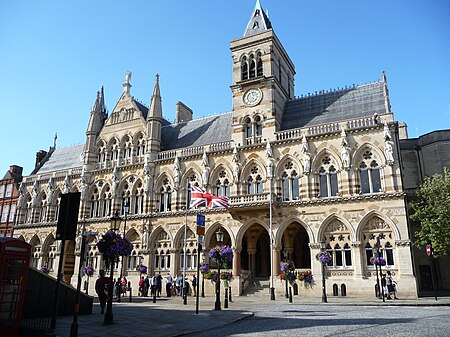
Northampton Guildhall 01

Northampton ( ) is a town and civil parish in Northamptonshire, England. It is the county town of Northamptonshire and the administrative centre of the unitary authority of West Northamptonshire. The town is situated on the River Nene, 60 miles (97 km) north-west of London and 50 miles (80 km) south-east of Birmingham. Northampton is one of the largest towns in England; the population of its urban area was recorded as 245,899 in the 2021 census.Archaeological evidence of settlement in the area dates to the Bronze Age, Romans and Anglo-Saxons. In the Middle Ages, the town rose to national significance with the establishment of Northampton Castle, an occasional royal residence which regularly hosted the Parliament of England. Medieval Northampton had many churches, monasteries and the University of Northampton, all enclosed by the town walls. It was granted a town charter by Richard I in 1189 and a mayor was appointed by King John in 1215. The town was also the site of two medieval battles, in 1264 and 1460. The town largely supported the Parliamentary Roundheads during the English Civil War, which prompted Charles II to order the destruction of the town walls and most of the castle. The Great Fire of Northampton in 1675 also destroyed much of the historic town. Northampton was soon rebuilt and grew rapidly with the industrial development of the 18th century. The town continued to expand with the arrival of the Grand Union Canal and the railways in the 19th century, becoming a centre for footwear and leather manufacture. Growth was limited following the World Wars until it was designated a New Town in 1968, accelerating development which has continued into the 21st century. Northampton unsuccessfully applied for city status four times; in 1992, 2000, 2002 and 2022.

Excerpt from the Wikipedia article Northampton (License: CC BY-SA 3.0, Authors, Images).

Northampton
Henry Bird Way,

Geographical coordinates (GPS) Address Nearby Places
placeShow on map

Wikipedia: NorthamptonContinue reading on Wikipedia

Geographical coordinates (GPS)

Latitude Longitude
N 52.2303748 ° E -0.8937527 °
placeShow on map

Address

Henry Bird Way

Henry Bird Way
NN4 8GG , Far Cotton and Delapre
England, United Kingdom
mapOpen on Google Maps

Northampton Guildhall 01
Share experience

Nearby Places

78 Derngate
78 Derngate

78 Derngate is a Grade II* listed Georgian house in the Cultural Quarter of Northampton, England, originally built in 1815. Its interior was extensively remodelled in 1916 and 1917 by the architect Charles Rennie Mackintosh for businessman Wenman Joseph Bassett-Lowke as his first marital home. Mackintosh's designs for the house are considered to be one of the first examples of the Art Deco style to be seen in Britain. The rear elevation also features an extension with two elevated balconies which, in 1916, overlooked meadowland to the edge of Northampton. The design origins of this extension have been the subject of some scholarly debate and a myth of Mackintosh as a modernist pioneer in his late career has persisted. Recent research suggests that Bassett-Lowke and Alexander Ellis Anderson (a Northampton-based architect who supervised the remodelling) may also have had a hand in the design of this structure as well as Mackintosh. In 1926 the Bassett-Lowkes moved to New Ways, a modernist house designed by Peter Behrens close to Abington Park; this house is also Grade II* listed.Between 1964 and 1993 the building was used by Northampton High School for girls, initially as offices but later as classrooms. In 2002 work started to restore the house to Mackintosh's original design. This work was under the direction of architects John McAslan + Partners and involved a team of specialist contractors for restoration, or replication of, the original features of the Mackintosh period scheme. After eighteen months of restoration, the house was opened to the public in late 2003. Small group guided tours or self-guided visits are available and provide an insight into this Mackintosh-designed house in England. A supporting museum adjoins 78 Derngate and is housed in number 80. In 2003, the Discovery Channel aired a documentary series hosted by Eric Knowles titled The House That Mackintosh Built. The series followed aspects of the property restoration as it was in progress. In May 2007 a new visitors centre at 82 Derngate was opened to provide further facilities and exhibitions for visitors. This building, also restored by John McAslan + Partners, houses a restaurant, art galleries, meeting rooms, shop, visitor reception and administration offices. A regular programme of exhibitions and events is offered and an active 'Friends of 78 Derngate' group continues to raise funds for ongoing development of the project. On 3 October 2013, Prince Richard, Duke of Gloucester, visited 78 Derngate to commemorate the 10th anniversary of its opening to the public.On 21 March 2017 a commemoration of the 100th anniversary of the marriage of W. J. Bassett-Lowke and Florence Jane Jones was held at 78 Derngate. A centenary exhibition, "Charles Rennie Mackintosh & The Great War" ran from 1 February – 29 April 2017. This comprised exhibits from the late career of Mackintosh and examined the wider context for his work on 78 Derngate against the background of the First World War. The exhibition was the largest display of Mackintosh design in England. A series of related events during the exhibition run featured experts giving public talks and workshops on related themes. Artist and television presenter Lachlan Goudie featured 78 Derngate in his BBC documentary, Charles Rennie Mackintosh: Glasgow's Neglected Genius. This was produced to mark the 150th anniversary of Mackintosh's birth and was first broadcast on BBC Two Scotland on 5 June 2018. Goudie assessed the work on 78 Derngate as "[t]he dazzling work of an artist willing to risk losing control", with the interior decor being presented as a bold 'comeback attempt' by Mackintosh which was to prove to be in vain against the background of the First World War.

Northampton's tunnels

According to some sources several tunnels run underneath the streets of the town of Northampton in England, along with many medieval cellars and ancient crypts. Much of the present town's development took place during medieval times, and some cellars from the period remain. Although some of these chambers are connected and others may have been connected in the past, it is doubtful if they ever have formed an extensive connected network.West Northamptonshire District Council say that to their knowledge there is only one tunnel which runs from All Saints Church across Mercers Row. The Northampton Chronicle and Echo published a plan of this provided by the Council showing the tunnel beginning on the north side of the church in Mercers Row where there was a man hole cover. The tunnel was then shown running eastwards across the mouth of Wood Hill where it turned north across the end of Abington Street into the Market Square on the east side just north of the junction with Abington Street The newspaper further reported that cellars which form part of the tunnel shown on the plan, along with other cellars nearby were used as air raid shelters during World War 2. An employee of the Shipmans Public House said the pub had a cellar with a door in it and there was a tunnel behind the door.Many of the medieval cellars are thought to have originated from the church buildings, that today are centred on All Saints Church – for instance underneath the Northampton & County Club in George Row (opposite the church) some fine vaulted cellars can be seen. There are similar tunnels on the other side of the church at Drum Lane – underneath the Shipman's public house. John Speed's map of Northampton from 1610 shows that the church was then the largest landowner in the town. Clashes took place over the years between the church and the monarchy – such as the banning of markets being held in the churchyards. It is thought that some of these tunnels were established as escape routes for clergy during times of trouble. The various religious houses in early times were found at all the main 8 compass points – giving rise to a series of radial tunnels heading out from All Saints Church at the centre of town to the various houses. Some tunnels had a more mundane function – channelling water from the springs on what is now the Racecourse and Springfield into the town centre. These conduits were known respectively as the Great and the Little Conduits. Northampton Castle was once one of the most important in the country and there is a suggestion that at least one tunnel linked the castle to All Saints Church – and even that such a tunnel might have been utilised by Thomas Becket in his escape from the castle and the town on his way to France. Another theory suggests that the cellars may have been used as a refuge from town fires common in timbered medieval towns such as Northampton – as seen in 1516. It is also thought that a tunnel may have allowed the nuns of Delapré Abbey, on the outskirts of the town to escape the Battle of Northampton (1460) which raged in their grounds. It is thought that this tunnel ran via St John's Church at the bottom of Bridge Street.