place

Northampton Museum and Art Gallery

Art museums and galleries in NorthamptonshireBuildings and structures in NorthamptonCity museums in the United KingdomLocal museums in NorthamptonshireShoe museums
Tourist attractions in NorthamptonUse British English from February 2023
NorthamptonMAG
NorthamptonMAG

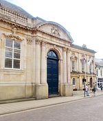
Northampton Museum and Art Gallery is a public museum in Northampton, England. The museum is owned and run by West Northamptonshire Council and houses one of the largest collection of shoes in the world, with over 15,000 pairs, which was designated by Arts Council England as being of local, national and international importance. The town's museum was established in 1865, but moved to the current site in 1884, where it shared its space with the town's library. After the library moved in 1910, the museum took over the whole building. The museum was extended in 1935 and again in 1988. In 2012, the museum was refurbished for better access.The museum closed between 2017 and 2021 for a major £6.7m expansion project. The new museum reopened in July 2021, more than a year later than planned due to the COVID-19 pandemic.

Excerpt from the Wikipedia article Northampton Museum and Art Gallery (License: CC BY-SA 3.0, Authors, Images).

Northampton Museum and Art Gallery
Guildhall Road,

Geographical coordinates (GPS) Address External links Nearby Places
placeShow on map

Wikipedia: Northampton Museum and Art GalleryContinue reading on Wikipedia

Geographical coordinates (GPS)

Latitude Longitude
N 52.2366 ° E -0.8946 °
placeShow on map

Address

Central Museum

Guildhall Road 4-6
NN1 1DP , Semilong
England, United Kingdom
mapOpen on Google Maps

linkWikiData (Q15262554)
linkOpenStreetMap (59194378)

NorthamptonMAG
NorthamptonMAG
Share experience

Nearby Places

Northampton War Memorial

Northampton War Memorial, officially the Town and County War Memorial, is a First World War memorial on Wood Hill in the centre of Northampton, the county town of Northamptonshire, in central England. Designed by architect Sir Edwin Lutyens, it is a Stone of Remembrance flanked by twin obelisks draped with painted stone flags standing in a small garden in what was once part of the churchyard of All Saints' Church. Discussion of a war memorial for Northampton began shortly after the armistice in 1918, and from July 1919 a temporary wooden cenotaph stood on Abington Street in the town centre. The Northamptonshire War Memorial Committee commissioned Lutyens to design a permanent memorial. The monument's design was completed and approved quickly, but its installation was delayed by six years until the site could be purchased from the Church of England, which required a faculty from the local diocese. The memorial was finally unveiled on 11 November 1926 after a service and a parade including local schoolchildren and civic leaders. Northampton's memorial is one of the more elaborate town memorials in England. It uses three features characteristic of Lutyens's war memorials: a pair of obelisks, the Stone of Remembrance (which Lutyens designed for the Imperial War Graves Commission), and painted stone flags on the obelisks, which were rejected for his Cenotaph in London but feature on several of his other memorials. Today it is a Grade I listed building; it was upgraded from Grade II in 2015 when Lutyens's war memorials were declared a "national collection" and all were granted listed building status or had their listing renewed.

Northampton's tunnels

According to some sources several tunnels run underneath the streets of the town of Northampton in England, along with many medieval cellars and ancient crypts. Much of the present town's development took place during medieval times, and some cellars from the period remain. Although some of these chambers are connected and others may have been connected in the past, it is doubtful if they ever have formed an extensive connected network.West Northamptonshire District Council say that to their knowledge there is only one tunnel which runs from All Saints Church across Mercers Row. The Northampton Chronicle and Echo published a plan of this provided by the Council showing the tunnel beginning on the north side of the church in Mercers Row where there was a man hole cover. The tunnel was then shown running eastwards across the mouth of Wood Hill where it turned north across the end of Abington Street into the Market Square on the east side just north of the junction with Abington Street The newspaper further reported that cellars which form part of the tunnel shown on the plan, along with other cellars nearby were used as air raid shelters during World War 2. An employee of the Shipmans Public House said the pub had a cellar with a door in it and there was a tunnel behind the door.Many of the medieval cellars are thought to have originated from the church buildings, that today are centred on All Saints Church – for instance underneath the Northampton & County Club in George Row (opposite the church) some fine vaulted cellars can be seen. There are similar tunnels on the other side of the church at Drum Lane – underneath the Shipman's public house. John Speed's map of Northampton from 1610 shows that the church was then the largest landowner in the town. Clashes took place over the years between the church and the monarchy – such as the banning of markets being held in the churchyards. It is thought that some of these tunnels were established as escape routes for clergy during times of trouble. The various religious houses in early times were found at all the main 8 compass points – giving rise to a series of radial tunnels heading out from All Saints Church at the centre of town to the various houses. Some tunnels had a more mundane function – channelling water from the springs on what is now the Racecourse and Springfield into the town centre. These conduits were known respectively as the Great and the Little Conduits. Northampton Castle was once one of the most important in the country and there is a suggestion that at least one tunnel linked the castle to All Saints Church – and even that such a tunnel might have been utilised by Thomas Becket in his escape from the castle and the town on his way to France. Another theory suggests that the cellars may have been used as a refuge from town fires common in timbered medieval towns such as Northampton – as seen in 1516. It is also thought that a tunnel may have allowed the nuns of Delapré Abbey, on the outskirts of the town to escape the Battle of Northampton (1460) which raged in their grounds. It is thought that this tunnel ran via St John's Church at the bottom of Bridge Street.