Tonypandy
AC with 0 elementsCommunities in Rhondda Cynon TafMid Glamorgan electoral wardsRhondda ValleyTowns in Rhondda Cynon Taf ... and 1 more
Wards of Rhondda Cynon Taf

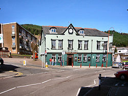
Tonypandy is a town, community and electoral ward located in the county borough of Rhondda Cynon Taf, within the historic county boundaries of Glamorgan, Wales, lying in the Rhondda Fawr Valley. A former industrial coal mining town, today Tonypandy is best known as the site of the 1910 Tonypandy riots. According to the 2011 UK Census, the population of the community was 3,750, though the population of the wider urban area was 17,789.
Excerpt from the Wikipedia article Tonypandy (License: CC BY-SA 3.0, Authors, Images).Tonypandy
Trealaw Road,
Geographical coordinates (GPS) Address Nearby Places Show on map
Geographical coordinates (GPS)
| Latitude | Longitude |
|---|---|
| N 51.6223 ° | E -3.4512 ° |
Address
Trealaw Road
Trealaw Road
CF40 2LG
Wales, United Kingdom
Open on Google Maps


