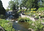
Lorette River

The Lorette River is a tributary of the Saint-Charles River, crossing the sector Sainte-Foy–Sillery–Cap-Rouge and the area of L'Ancienne-Lorette in Quebec City, in the administrative region of Capitale-Nationale, in the province of Quebec, Canada. The Lorette river valley is mainly served by various urban roads, notably the route 358 (avenue Notre-Dame), boulevard Chauveau Ouest, rue Saint-Olivier, rue Saint- Jean-Baptiste, rue Saint-Paul, route 138 (boulevard Wilfrid-Hamel), boulevard du Parc-Technologique and boulevard Masson.The surface of the Lorette River (except the rapids areas) is generally frozen from the beginning of December to the end of March; safe circulation on the ice is generally done from the end of December to the beginning of March. The water level of the river varies with the seasons and the precipitation; the spring flood occurs in March or April.
Excerpt from the Wikipedia article Lorette River (License: CC BY-SA 3.0, Authors, Images).Lorette River
Boulevard Masson, Quebec Les Saules (Les Rivières)
Geographical coordinates (GPS) Address Nearby Places Show on map
 Continue reading on Wikipedia
 Geographical coordinates (GPS)
| Latitude | Longitude |
|---|---|
| N 46.808333333333 ° | E -71.317777777778 ° |
Address
Boulevard Masson 2186
G1P 1J4 Quebec, Les Saules (Les Rivières)
Quebec, Canada
Open on Google Maps