Louis-Hébert (provincial electoral district)
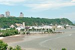
Louis-Hébert is a provincial electoral district in the Capitale-Nationale region of Quebec, Canada. It consists of part of the Sainte-Foy–Sillery–Cap-Rouge borough of Quebec City (specifically the neighbourhoods of Cap-Rouge, Champigny, Jouvence, Quartier Laurentien, Lorette, Les Grands-Déserts and parts of Pointe-de-Sainte-Foy and Place-Notre-Dame), as well as all of Saint-Augustin-de-Desmaures. It was created for the 1966 election from parts of Québec-Comté and Québec-Ouest and a small part of Portneuf electoral districts. In the change from the 2001 to the 2011 electoral map, it gained Saint-Augustin-de-Desmaures from La Peltrie; it also gained part of Quebec City from La Peltrie, but lost part of the city to Jean-Talon. The riding was named after the first legal farmer of New France, Louis Hébert.
Excerpt from the Wikipedia article Louis-Hébert (provincial electoral district) (License: CC BY-SA 3.0, Authors).Louis-Hébert (provincial electoral district)
Rue Pouliot, Quebec Saint-Louis (Sainte-Foy–Sillery–Cap-Rouge)
Geographical coordinates (GPS) Address Nearby Places Show on map
 Continue reading on Wikipedia
 Geographical coordinates (GPS)
| Latitude | Longitude |
|---|---|
| N 46.775 ° | E -71.297222222222 ° |
Address
Rue Pouliot 933
G1V 2X8 Quebec, Saint-Louis (Sainte-Foy–Sillery–Cap-Rouge)
Quebec, Canada
Open on Google Maps