place

Hackthorn

Civil parishes in LincolnshireLincolnshire geography stubsUse British English from February 2014Villages in LincolnshireWest Lindsey District
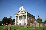
St.Michael's church, Hackthorn, Lincs. geograph.org.uk 100262

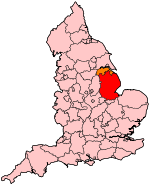
Hackthorn is a village and civil parish in the West Lindsey district of Lincolnshire, England. It is combined with Cold Hanworth to form the parish council of Hackthorn and Cold Hanworth. The population of the civil parish (including Cold Hanworth) at the 2011 census was 207. It is situated approximately 6 miles (10 km) north from the city and county town of Lincoln, and 1 mile (1.6 km) east from the A15. According to the 2001 Census it had a population of 180. The village is part of the Owmby Group of parishes.The village dates back to Roman times. Its most prominent building is its hall, a large square brick house, built in the late 18th century in a landscaped park of around 100 acres (0.40 km2).Situated among the trees of the park overlooking the lake is the parish church, dedicated to St Michael and All Angels. A village church is mentioned in the Domesday Book, although the present church is a Victorian gothic building. It contains carved woodwork in the reredos screen and gallery, and an 1869 Nicholson Organ, fully restored in 2006. There is also a primary school, post office, shop and village hall.

Excerpt from the Wikipedia article Hackthorn (License: CC BY-SA 3.0, Authors, Images).

Hackthorn
Main Street, West Lindsey

Geographical coordinates (GPS) Address Nearby Places
placeShow on map

Wikipedia: HackthornContinue reading on Wikipedia

Geographical coordinates (GPS)

Latitude Longitude
N 53.32883 ° E -0.50765 °
placeShow on map

Address

Main Street

Main Street
LN2 3PF West Lindsey
England, United Kingdom
mapOpen on Google Maps

St.Michael's church, Hackthorn, Lincs. geograph.org.uk 100262
Share experience

Nearby Places

Grange de Lings
Grange de Lings

Grange de Lings is a civil parish in the West Lindsey district of Lincolnshire, England. It is situated 3 miles (5 km) north from the city centre of the county town of Lincoln. Grange de Lings is often quoted as the address for the Lincolnshire Showground, just off the west of the A15, but the parish actually lies entirely east of the A15, and the Lincolnshire Showground is in the parish of North Carlton. The parish is sometimes hyphenated as Grange-de-Lings. The north-western corner of the parish is at the A1500 junction with the A15, at a roundabout. The boundary follows Horncastle Lane eastwards where it neighbours Welton, to the north. At Dunholme, it follows southwards across the old runways of RAF Dunholme Lodge, of which the western end was in Grange de Lings. It briefly meets Scothern, and a small section of the parish extends between Scothern and Nettleham, to meet the A46, which it follows for around 200 metres. The boundary with Nettleham passes westwards, then south-west across Hall Lane, then meets Riseholme, where it follows a line due west to the A15 (Ermine Street), meeting South Carlton just south of the pylons across the A15. The western boundary of the parish is the A15, and just north of Watering Dyke Houses, it meets North Carlton at the perimeter fence of the Lincolnshire Showground (wholly outside the parish). There is an oil well in the north of the parish, next to the boundary with Welton, part of the East Midlands Oil Province. The parish has no parish church, but is part of the St Mary's church in the Riseholme with Grange de Lings parish, looked after by Nettleham parish, where the vicar is based. Grange-de-Lings in this respect is known as an extra-parochial district. For statistical and administrative purposes, it is joined with Riseholme (similar to the religious parish)