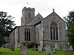
Hevingham
BroadlandCivil parishes in NorfolkEngvarB from July 2016Villages in Norfolk

Hevingham is a village and civil parish in the Broadland district of the English county of Norfolk. Situated between the A140 road Norwich to Cromer road and the B1149 road Norwich to Holt road. It is 7 miles (11 km) north from the city of Norwich and 4 miles (6.4 km) south from the market town of Aylsham. Hevingham parish covers a wide area—11.66 square kilometres (4.50 sq mi). The village has grown slightly since the 1891 census (which showed a population of 760) to its level of 1,150 in 452 households as shown in 2001 census. then a population of 1,260 in 485 households at the 2011 Census.
Excerpt from the Wikipedia article Hevingham (License: CC BY-SA 3.0, Authors, Images).Hevingham
Town Corner, Broadland Hevingham
Geographical coordinates (GPS) Address Nearby Places Show on map
Geographical coordinates (GPS)
| Latitude | Longitude |
|---|---|
| N 52.74382 ° | E 1.26291 ° |
Address
Town Corner
Town Corner
NR10 5LZ Broadland, Hevingham
England, United Kingdom
Open on Google Maps


