place

Humber Heights-Westmount

AC with 0 elementsEtobicokeNeighbourhoods in Toronto
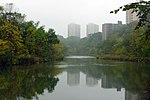
Looking west to Raymore Park 2

Humber Heights-Westmount, also known as Humbervale, is a neighbourhood in Etobicoke, Toronto, Ontario. The neighbourhood is bounded by the west bank of the Humber River, west to Royal York Road and south to Eglinton Avenue West. The Humber Creek divides the area into the northern 'Humber Heights' (originally the Etobicoke side of York Township's Weston) and the southern 'Westmount' (originally part of the 'Richview' farming district) centred along Scarlett Road and La Rose Avenue. 'Richview' district (and Richview Sideroad) originated in Westmount at Scarlett Road (at the now Eglinton Avenue intersection) and its elevation in the scenic neighbourhood gave birth to the name 'rich'-'view'. Richview Sideroad was changed to Eglinton Avenue in 1970 when a 4-lane bridge was built from the east side of the Humber River to Scarlett Road in Etobicoke. This caused the morphing of Richview Sideroad with Eglinton Avenue, and the name-change. Toronto City planners had hoped to turn Richview Sideroad into The Richview Expressway to connect mid-town Toronto to the western townships down to Hamilton. Local opposition from Westmount/James Gardens/Richmond Gardens districts put up strong and influential fight to eventually kill the plan.

Excerpt from the Wikipedia article Humber Heights-Westmount (License: CC BY-SA 3.0, Authors, Images).

Humber Heights-Westmount
Lawrence Avenue West, Toronto Etobicoke

Geographical coordinates (GPS) Address Nearby Places
placeShow on map

Wikipedia: Humber Heights-WestmountContinue reading on Wikipedia

Geographical coordinates (GPS)

Latitude Longitude
N 43.697222222222 ° E -79.525833333333 °
placeShow on map

Address

The Village of Humber Heights

Lawrence Avenue West 2245
M9P 3W3 Toronto, Etobicoke
Ontario, Canada
mapOpen on Google Maps

Looking west to Raymore Park 2
Share experience

Nearby Places

Central United Church

Central United Church is a historic congregation of the United Church of Canada located in the community of Weston, now a neighbourhood of Toronto, Ontario, Canada. Founded in 1821 (1821), the church has occupied the same site on Weston Road in Toronto since then.The congregation began as part of the Methodist Episcopal Church, a forerunner of both the Methodist Church of Canada (1884) and the United Church of Canada (1925). The first church building, a log structure, was erected in 1821, followed by a larger brick church constructed in 1849. The present building, dedicated in 1887, and built in the Gothic Revival style, has been altered and updated on several occasions, but retains the landmark tower. The tower includes examples of abat-sons. The church was one of the final projects of William Henry Mallory Sr., architect.The congregation has a unique musical heritage. The organ, constructed by Casavant Frères, was dedicated in 1950 as a memorial to members of the congregation who gave their lives in the Second World War. The Chancellors, a youth choir active from 1968 to 1980, produced five record albums and toured extensively. The congregation has been served by several notable clergy, including Egerton Ryerson, historian George Playter and E.A. Pearson, the father of Prime Minister Lester B. Pearson. Today, the church is well known for outreach into the community through the Weston King Neighbourhood Centre. The Centre provides meals, education and advocacy.