Ingleside, New South Wales
Northern Beaches CouncilSuburbs of SydneySydney geography stubsUse Australian English from February 2015

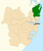
Ingleside is a suburb in Northern Sydney, in the state of New South Wales, Australia. Ingleside is located 28 kilometres north of the Sydney central business district, in the local government area of Northern Beaches Council. Ingleside is part of the Forest District region, about 2 kilometres from the coast at Mona Vale. Ingleside Heights and Tumbledown Dick are localities in the west of the suburb. The area is mostly semi-rural properties and bushland with increasing housing developments.
Excerpt from the Wikipedia article Ingleside, New South Wales (License: CC BY-SA 3.0, Authors, Images).Ingleside, New South Wales
Waratah Road, Sydney Ingleside
Geographical coordinates (GPS) Address Nearby Places Show on map
Geographical coordinates (GPS)
| Latitude | Longitude |
|---|---|
| N -33.6823 ° | E 151.26315 ° |
Address
Waratah Road
Waratah Road
2101 Sydney, Ingleside
New South Wales, Australia
Open on Google Maps


