Battlesbridge railway station

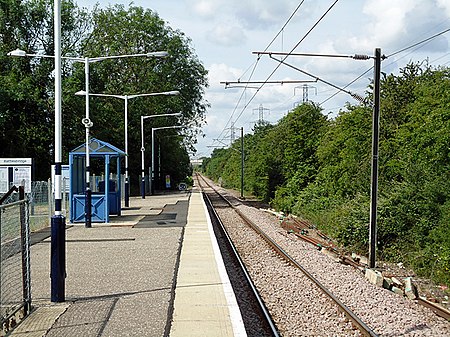
Battlesbridge railway station is on the Crouch Valley Line in the East of England, serving the village of Battlesbridge, Essex. It is 31 miles 40 chains (50.7 km) down the line from London Liverpool Street and is situated between Wickford to the west and South Woodham Ferrers to the east. The Engineer's Line Reference for the line is WIS; the station's three-letter station code is BLB. The line and station were opened on 1 June 1889 for goods and on 1 October 1889 for passenger services by the Great Eastern Railway. The station had a single platform with a station building, a goods shed, a goods yard including cattle pens, and a 34-lever signal box. The freight service was withdrawn on 4 October 1965; the goods loop and signal box were closed on 7 December 1966. All the station buildings were demolished in 1968. Electrification of the Wickford to Southminster line using 25 kV overhead line electrification (OLE) was completed on 12 May 1986. Battlesbridge station is currently managed by Greater Anglia, which also operates all trains serving it. The typical off-peak service is of one westbound train every 40 minutes to Wickford (with some peak-hour services continuing to Shenfield and/or London Liverpool Street) and one eastbound train every 40 minutes to Southminster. Since the platform is only long enough to accommodate eight carriages, any peak-hour trains formed of 12 coaches do not call at Battlesbridge.
Excerpt from the Wikipedia article Battlesbridge railway station (License: CC BY-SA 3.0, Authors, Images).Battlesbridge railway station
Hawk Hill, Chelmsford Rettendon
Geographical coordinates (GPS) Address External links Nearby Places Show on map
Geographical coordinates (GPS)
| Latitude | Longitude |
|---|---|
| N 51.625 ° | E 0.566 ° |
Address
Battlesbridge
Hawk Hill
SS11 7RG Chelmsford, Rettendon
England, United Kingdom
Open on Google Maps


