Vanport, Oregon
1943 establishments in Oregon1948 disestablishments in OregonAfrican-American history in Portland, OregonAfrican-American history of OregonCompany towns in Oregon ... and 12 more
East Columbia, Portland, OregonFormer populated places in OregonHenry J. KaiserHistory of Portland, OregonHistory of racism in OregonKenton, Portland, OregonMultnomah County, OregonNatural disasters in OregonNorth Portland, OregonPopulated places disestablished in 1948Populated places established in 1943Use mdy dates from May 2018

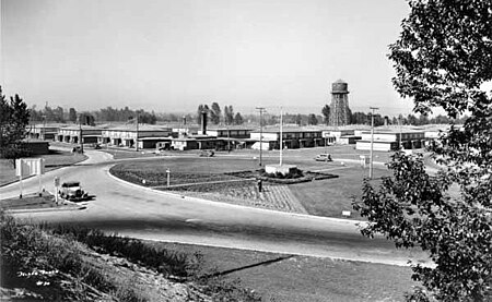
Vanport, sometimes referred to as Vanport City or Kaiserville, was a city of wartime public housing in Multnomah County, Oregon, United States, between the contemporary Portland city boundary and the Columbia River. It was destroyed in the 1948 Columbia River flood and not rebuilt. It sat on what is currently the site of Delta Park and the Portland International Raceway.
Excerpt from the Wikipedia article Vanport, Oregon (License: CC BY-SA 3.0, Authors, Images).Vanport, Oregon
North Victory Boulevard, Portland Kenton
Geographical coordinates (GPS) Address Website Nearby Places Show on map
Geographical coordinates (GPS)
| Latitude | Longitude |
|---|---|
| N 45.601944444444 ° | E -122.7 ° |
Address
Heron Lakes Golf Course (Heron Lakes Golf Club)
North Victory Boulevard 3500
97217 Portland, Kenton
Oregon, United States
Open on Google Maps


