Shutlingsloe

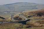
Shutlingsloe is a hill near the village of Wildboarclough, in the east of the county of Cheshire. It stands to the south of Macclesfield Forest, on the edge of the Peak District and within the Peak District National Park.A steep-sided hill with a distinctive profile, sometimes described as the 'Matterhorn of Cheshire', it is the third highest peak in the historic county (Black Hill being the highest and Shining Tor second highest) with an elevation of 506 m (1,660 ft) and commands excellent views over Cheshire. The Peak District Boundary Walk crosses the summit, which is the highest point on the footpath's 200-mile long route.The name derives from old English 'Scyttel's hlaw' meaning 'Scyttel's (personal name) hill' and is one of several 'low' names in the Peak District, from the same Old English root that gives rise to the name "Law" for many hills in southern Scotland.
Excerpt from the Wikipedia article Shutlingsloe (License: CC BY-SA 3.0, Authors, Images).Shutlingsloe
Forest Bridleway,
Geographical coordinates (GPS) Address Nearby Places Show on map
Geographical coordinates (GPS)
| Latitude | Longitude |
|---|---|
| N 53.22321 ° | E -2.03673 ° |
Address
Forest Bridleway
SK11 0AR , Macclesfield Forest and Wildboarclough
England, United Kingdom
Open on Google Maps


