Dang Wangi
Malaysia geography stubsSuburbs in Kuala Lumpur
.JPG)
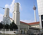
Dang Wangi is an area in the city centre of Kuala Lumpur, Malaysia, situated north of Dataran Merdeka, bordering Bukit Nanas and Medan Tuanku and located between the Gombak and Klang Rivers. The name is derived from Hang Jebat's wife. A road that cuts across the ward, Dang Wangi Road (Malay: Jalan Dang Wangi), formerly known as Campbell Road, is named after the ward. Running in an east–west orientation, it interchanges into Jalan Tuanku Abdul Rahman on its western end and Jalan Ampang on its eastern end. The KJ12 Dang Wangi LRT Station, part of the KJ Line, is located on the northeast side of the district.
Excerpt from the Wikipedia article Dang Wangi (License: CC BY-SA 3.0, Authors, Images).Dang Wangi
Campbell Road, Kuala Lumpur Bukit Bintang
Geographical coordinates (GPS) Address Nearby Places Show on map
 Continue reading on Wikipedia
 Geographical coordinates (GPS)
| Latitude | Longitude |
|---|---|
| N 3.1566388888889 ° | E 101.69783333333 ° |
Address
Ibu Pejabat Polis Daerah Dang Wangi
Campbell Road
50100 Kuala Lumpur, Bukit Bintang
Malaysia
Open on Google Maps