A Kung Ngam
A Kung NgamEastern District, Hong KongHong Kong Island geography stubsUse Hong Kong English from April 2019

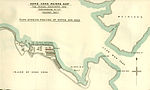
A Kung Ngam (Chinese: 阿公岩) is a village and an area in northeast Shau Kei Wan in the north of Hong Kong Island, in Hong Kong. It contains a fish terminal market, several temples and the Hong Kong Museum of Coastal Defence.
Excerpt from the Wikipedia article A Kung Ngam (License: CC BY-SA 3.0, Authors, Images).A Kung Ngam
Tam Kung Temple Road, Hong Kong Island Shau Kei Wan (Eastern District)
Geographical coordinates (GPS) Address Nearby Places Show on map
 Continue reading on Wikipedia
 Geographical coordinates (GPS)
| Latitude | Longitude |
|---|---|
| N 22.28303 ° | E 114.23142 ° |
Address
筲箕灣基本污水處理廠 Shau Kei Wan Basic Sewage Treatment Plant
Tam Kung Temple Road
Hong Kong Island, Shau Kei Wan (Eastern District)
Hong Kong, China
Open on Google Maps