place

Wraysbury railway station

1861 establishments in EnglandBuildings and structures in the Royal Borough of Windsor and MaidenheadFormer London and South Western Railway stationsPages with no open date in Infobox stationRailway stations in Berkshire
Railway stations in Great Britain opened in 1861Railway stations served by South Western RailwaySouth East England railway station stubsUse British English from December 2016
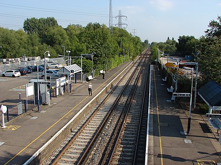
Wraysbury Station (geograph 3646075)

Wraysbury railway station serves the village of Wraysbury in Berkshire, England, as well as the larger villages of Stanwell Moor and Poyle. It is 21 miles 40 chains (34.6 km) down the line from London Waterloo. The station is on the line between Windsor and Eton Riverside and Waterloo. Services are operated by South Western Railway. As part of the proposed AirTrack rail link, a new station, to be called Staines High Street railway station would be built between Wraysbury and Staines railway station. This proposal (involving rebuilding a former station) has been in doubt for some years.

Excerpt from the Wikipedia article Wraysbury railway station (License: CC BY-SA 3.0, Authors, Images).

Wraysbury railway station
Station Road,

Geographical coordinates (GPS) Address Nearby Places
placeShow on map

Wikipedia: Wraysbury railway stationContinue reading on Wikipedia

Geographical coordinates (GPS)

Latitude Longitude
N 51.458 ° E -0.542 °
placeShow on map

Address

Station Road
TW19 5NJ
England, United Kingdom
mapOpen on Google Maps

Wraysbury Station (geograph 3646075)
Share experience

Nearby Places

Ankerwycke Yew
Ankerwycke Yew

The Ankerwycke Yew is an ancient yew tree close to the ruins of St Mary's Priory, the site of a Benedictine nunnery built in the 12th century, near Wraysbury in Berkshire, England. It is a male tree with a girth of 8 metres (26 ft) at 0.3 metres. The tree is at least 1,400 years old, and could be as old as 2,500 years.On the opposite bank of the River Thames are the meadows of Runnymede and this tree is said to have been witness to the signing of Magna Carta. The tree is also said to be the location where Henry VIII courted Anne Boleyn in the 1530s. Here the confederate Barons met King John, and having forced him to yield to the demands of his subjects they, under the pretext of securing the person of the King from the fury of the multitude, conveyed him to a small island belonging to the nuns of Ankerwyke [the island], where he signed the Magna Carta. There is some justification for the theory that the Ankerwycke Yew could be "the last surviving witness to the sealing of the Magna Carta 800 years ago". "In the 13th century, the landscape would have been different as the area was probably rather marshy as it was within the flood plain of the Thames. The Ankerwycke Yew is on a slightly raised area of land (therefore dry) and with the proximity of the Priory perhaps both lend some credibility to this claim."The Ankerwycke Yew is situated on lands managed by the National Trust. In 2002 it was designated one of fifty Great British Trees by The Tree Council.